


METADATA
Griglia batimetrica in formato testo (griglia x-y-z) con risoluzione di 1 punto ogni 200 m.
PCM - Dipartimento della Protezione Civile
PCM - Dipartimento della Protezione Civile
E-mail: ufficio.pre@protezionecivile.it
Website: http://www.protezionecivile.gov.it
Griglia batimetrica in formato testo (griglia x-y-z) con risoluzione di 1 punto ogni 200 m.
PCM - Dipartimento della Protezione Civile
PCM - Dipartimento della Protezione Civile
E-mail: ufficio.pre@protezionecivile.it
Website: http://www.protezionecivile.gov.it
Piano Regolatore Generale Comunale. Tavola M3. Indica gli usi presenti e prevalenti per singole porzioni di territorio.
Regione Autonoma Valle d'Aosta
RAVDA - Ufficio Cartografico
E-mail: u-cartografia@regione.vda.it
Website: https://geoportale.regione.vda.it
Griglia batimetrica in formato testo (griglia x-y-z) con risoluzione di 1 punto ogni 200 m.
PCM - Dipartimento della Protezione Civile
PCM - Dipartimento della Protezione Civile
E-mail: ufficio.pre@protezionecivile.it
Website: http://www.protezionecivile.gov.it
Griglia batimetrica in formato testo (griglia x-y-z) con risoluzione di 1 punto ogni 50 m.
PCM - Dipartimento della Protezione Civile
PCM - Dipartimento della Protezione Civile
E-mail: ufficio.pre@protezionecivile.it
Website: http://www.protezionecivile.gov.it
Principali itinirari di valore storico e storico ambientale, presenti nella tavola 4 del PTRC approvato nel 1992
Regione del Veneto
Regione Veneto, Sezione Pianificazione Territoriale Strategica e Cartografia
E-mail: ptrc.cartografia@regione.veneto.it
Website: http://ptrc.regione.veneto.it
Griglia batimetrica in formato testo (griglia x-y-z) con risoluzione di 1 punto ogni 100 m.
PCM - Dipartimento della Protezione Civile
PCM - Dipartimento della Protezione Civile
E-mail: ufficio.pre@protezionecivile.it
Website: http://www.protezionecivile.gov.it
Griglia batimetrica in formato testo (griglia x-y-z) con risoluzione di 1 punto ogni 200 m.
PCM - Dipartimento della Protezione Civile
PCM - Dipartimento della Protezione Civile
E-mail: ufficio.pre@protezionecivile.it
Website: http://www.protezionecivile.gov.it
Griglia batimetrica in formato testo (griglia x-y-z) con risoluzione di 1 punto ogni 50 m.
PCM - Dipartimento della Protezione Civile
PCM - Dipartimento della Protezione Civile
E-mail: ufficio.pre@protezionecivile.it
Website: http://www.protezionecivile.gov.it
Griglia batimetrica in formato testo (griglia x-y-z) con risoluzione di 1 punto ogni 200 m.
PCM - Dipartimento della Protezione Civile
PCM - Dipartimento della Protezione Civile
E-mail: ufficio.pre@protezionecivile.it
Website: http://www.protezionecivile.gov.it
Griglia batimetrica in formato testo (griglia x-y-z) con risoluzione di 1 punto ogni 200 m.
PCM - Dipartimento della Protezione Civile
PCM - Dipartimento della Protezione Civile
E-mail: ufficio.pre@protezionecivile.it
Website: http://www.protezionecivile.gov.it
Griglia batimetrica in formato testo (griglia x-y-z) con risoluzione di 1 punto ogni 100 m.
PCM - Dipartimento della Protezione Civile
PCM - Dipartimento della Protezione Civile
E-mail: ufficio.pre@protezionecivile.it
Website: http://www.protezionecivile.gov.it
Griglia batimetrica in formato testo (griglia x-y-z) con risoluzione di 1 punto ogni 100 m.
PCM - Dipartimento della Protezione Civile
PCM - Dipartimento della Protezione Civile
E-mail: ufficio.pre@protezionecivile.it
Website: http://www.protezionecivile.gov.it
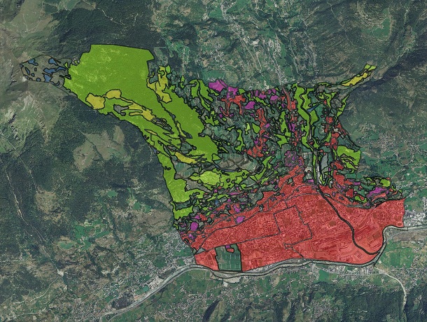
Il dato, areale, rappresenta i sistemi paesaggistici agroforestali di particolare interdigitazione tra aree coltivate e bordi boscati
Regione Piemonte
Regione Piemonte - A1610C - Pianificazione regionale per il governo del territorio
E-mail: piano.paesaggistico@regione.piemonte.it
Website: https://www.regione.piemonte.it/web/temi/ambiente-territorio/paesaggio/piano-paesaggistico-regionale-ppr
Griglia batimetrica in formato testo (griglia x-y-z) con risoluzione di 1 punto ogni 100 m.
PCM - Dipartimento della Protezione Civile
PCM - Dipartimento della Protezione Civile
E-mail: ufficio.pre@protezionecivile.it
Website: http://www.protezionecivile.gov.it