METADATA
LE AREE PERCORSE DAL FUOCO SONO RIFERITE AGLI EVENTI VERIFICATISI DAL 2003 FINO AL 2010. SONO STATE RILEVATE DAI COMANDI STAZIONE DEL CORPO FORESTALE DELLO STATO DELLA LIGURIA ED ACQUISITE DAGLI UFFICI DEL MEDESIMO CORPO FORESTALE. I DATI NON SONO VALIDI ...
Regione Liguria
Regione Liguria - INFORMATICA -
E-mail: infoter@regione.liguria.it
Website: https://geoportal.regione.liguria.it

LE AREE PERCORSE DAL FUOCO SONO RIFERITE AGLI EVENTI VERIFICATISI NEL 2011. SONO STATE RILEVATE DAI COMANDI STAZIONE DEL CORPO FORESTALE DELLO STATO DELLA LIGURIA ED ACQUISITE DAGLI UFFICI DEL MEDESIMO CORPO FORESTALE. I DATI NON SONO VALIDI AI SENSI DEL ...
Regione Liguria
Regione Liguria - Sportello cartografico
E-mail: infoter@regione.liguria.it
Website: https://geoportal.regione.liguria.it
LE AREE PERCORSE DAL FUOCO SONO RIFERITE AGLI EVENTI VERIFICATISI NEL 2018. SONO STATE RILEVATE DAL COMANDO REGIONE CARABINIERI FORESTALE "LIGURIA" ED ACQUISITE DAGLI UFFICI DEL MEDESIMO COMANDO. I DATI NON SONO VALIDI AI SENSI DEL COMMA 2, ART. 10 DELLA ...
Regione Liguria
Regione Liguria - Sportello cartografico
E-mail: infoter@regione.liguria.it
Website: https://geoportal.regione.liguria.it
LE AREE PERCORSE DAL FUOCO SONO RIFERITE AGLI EVENTI VERIFICATISI NEL 2016. SONO STATE RILEVATE DAI COMANDI STAZIONE DEL CORPO FORESTALE DELLO STATO DELLA LIGURIA ED ACQUISITE DAGLI UFFICI DEL MEDESIMO CORPO FORESTALE. I DATI NON SONO VALIDI AI SENSI DEL ...
Regione Liguria
Regione Liguria - Sportello cartografico
E-mail: infoter@regione.liguria.it
Website: https://geoportal.regione.liguria.it
LE AREE PERCORSE DAL FUOCO SONO RIFERITE AGLI EVENTI VERIFICATISI NEL 2015. SONO STATE RILEVATE DAI COMANDI STAZIONE DEL CORPO FORESTALE DELLO STATO DELLA LIGURIA ED ACQUISITE DAGLI UFFICI DEL MEDESIMO CORPO FORESTALE. I DATI NON SONO VALIDI AI SENSI DEL ...
Regione Liguria
Regione Liguria - Sportello cartografico
E-mail: infoter@regione.liguria.it
Website: https://geoportal.regione.liguria.it
LE AREE PERCORSE DAL FUOCO SONO RIFERITE AGLI EVENTI VERIFICATISI NEL 2016. SONO STATE RILEVATE DAI COMANDI STAZIONE DEL CORPO FORESTALE DELLO STATO DELLA LIGURIA ED ACQUISITE DAGLI UFFICI DEL MEDESIMO CORPO FORESTALE. I DATI NON SONO VALIDI AI SENSI DEL ...
Regione Liguria
Regione Liguria - Sportello cartografico
E-mail: infoter@regione.liguria.it
Website: https://geoportal.regione.liguria.it
LE AREE PERCORSE DAL FUOCO SONO RIFERITE AGLI EVENTI VERIFICATISI NEL 2017. SONO STATE RILEVATE DAL COMANDO REGIONE CARABINIERI FORESTALE "LIGURIA" ED ACQUISITE DAGLI UFFICI DEL MEDESIMO COMANDO. I DATI NON SONO VALIDI AI SENSI DEL COMMA 2, ART. 10 DELLA ...
Regione Liguria
Regione Liguria - Sportello cartografico
E-mail: infoter@regione.liguria.it
Website: https://geoportal.regione.liguria.it
LE AREE PERCORSE DAL FUOCO SONO RIFERITE AGLI EVENTI VERIFICATISI NEL 2012. SONO STATE RILEVATE DAI COMANDI STAZIONE DEL CORPO FORESTALE DELLO STATO DELLA LIGURIA ED ACQUISITE DAGLI UFFICI DEL MEDESIMO CORPO FORESTALE. I DATI NON SONO VALIDI AI SENSI DEL ...
Regione Liguria
Regione Liguria - Sportello cartografico
E-mail: infoter@regione.liguria.it
Website: https://geoportal.regione.liguria.it
LE AREE PERCORSE DAL FUOCO SONO RIFERITE AGLI EVENTI VERIFICATISI NEL 2013. SONO STATE RILEVATE DAI COMANDI STAZIONE DEL CORPO FORESTALE DELLO STATO DELLA LIGURIA ED ACQUISITE DAGLI UFFICI DEL MEDESIMO CORPO FORESTALE. I DATI NON SONO VALIDI AI SENSI DEL ...
Regione Liguria
Regione Liguria - Sportello cartografico
E-mail: infoter@regione.liguria.it
Website: https://geoportal.regione.liguria.it
LE AREE PERCORSE DAL FUOCO SONO RIFERITE AGLI EVENTI VERIFICATISI NEL 2011. SONO STATE RILEVATE DAI COMANDI STAZIONE DEL CORPO FORESTALE DELLO STATO DELLA LIGURIA ED ACQUISITE DAGLI UFFICI DEL MEDESIMO CORPO FORESTALE. I DATI NON SONO VALIDI AI SENSI DEL ...
Regione Liguria
Regione Liguria - Sportello cartografico
E-mail: infoter@regione.liguria.it
Website: https://geoportal.regione.liguria.it
LE AREE PERCORSE DAL FUOCO SONO RIFERITE AGLI EVENTI VERIFICATISI NEL 2019. SONO STATE RILEVATE DAL COMANDO REGIONE CARABINIERI FORESTALE "LIGURIA" ED ACQUISITE DAGLI UFFICI DEL MEDESIMO COMANDO. I DATI NON SONO VALIDI AI SENSI DEL COMMA 2, ART. 10 DELLA ...
Regione Liguria
Regione Liguria - Sportello cartografico
E-mail: infoter@regione.liguria.it
Website: https://geoportal.regione.liguria.it
Cartografia di base del territorio regionale realizzata con il metodo fotogrammetrico, per lotti e in epoche diverse comprese tra il 1985 e il 2004.
Regione Umbria
Regione Umbria - SIAT
E-mail: umbriageo@regione.umbria.it
Website: http://www.umbriageo.regione.umbria.it

Selezione ed estrazione siti estrattivi, cave, rappresentati sulla cartografia costituente la Variante PUP 2000 approvata con Legge provinciale n°7 del 7 agosto 2003.
Provincia Autonoma di Trento
Provincia Autonoma di Trento - Servizio Urbanistica e Tutela del Paesaggio
E-mail: serv.urbanistica@provincia.tn.it
Website: http://www.urbanistica.provincia.tn.it
Territorio del Comune di Milano in tavole formato DWG. Sistema di riferimento ETRF2000. Quote di gronda, colmo e base degli edifici rilevabili da terna di punti presente all'interno di ciascuno.
Comune di Milano
Comune di Milano
E-mail: geoportale@comune.milano.it
Website: www.comune.milano.it
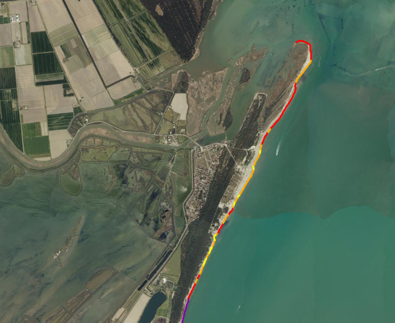
Lo strato cartografico contiene la classificazione della linea di costa 2023 basata sulla quota media della spiaggia emersa libera da infrastrutture permanenti. Il tratto di costa regionale analizzato è tra Cattolica (RN) e la Foce del Po di Volano. La ...
Regione Emilia-Romagna
Luisa Perini - Area Geologia, Suoli e Sismica - Settore Difesa del Territorio - Regione Emilia-Romagna
E-mail: luisa.perini@regione.emilia-romagna.it
Website: https://ambiente.regione.emilia-romagna.it/it/geologia