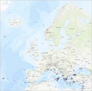
 OPENIACS Project - Geo Spatial Aid Application (GSAA) 2018 - Italy
The Open LOD platform based on HPC capabilities for Integrated Administration and Control System of Common Agrarian Policy (Open IACS) project, funded by the European Commission through the Innovation and Networks Executive Agency (INEA), was launched in ...
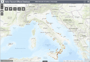 ITED (Italian Tsunami Effects Database) is the first database of descriptions of tsunami effects observed along the Italian coasts from 79 A.D. to date and was created as an extension of the Italian part of EMTC. ITED provides information on how much and ...
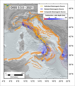 DISS is a georeferenced repository of tectonic, fault, and paleoseismological information. The core objects of DISS are:
- the individual seismogenic source, a simplified and three-dimensional representation of a fault plane. Individual seismogenic sourc...
DISS is a georeferenced repository of tectonic, fault, and paleoseismological information. The core objects of DISS are:
- the individual seismogenic source, a simplified and three-dimensional representation of a fault plane. Individual seismogenic sourc...
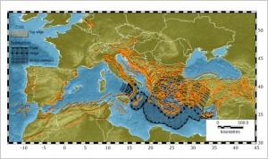 The European Database of Seismogenic Faults (EDSF) was compiled in the framework of the EU Project SHARE, Work Package 3, Task 3.2. EDSF includes only faults that are deemed to be capable of generating earthquakes of magnitude equal to or larger than 5.5 ...
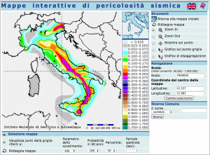 The probabilistic seismic hazard maps of the Italian national territory are represented by shaking parameters on a regular grid spaced by 0.05° and using two shaking parameters, PGA (horizontal peak ground acceleration) and Sa(spectral acceleration).
Map...
The probabilistic seismic hazard maps of the Italian national territory are represented by shaking parameters on a regular grid spaced by 0.05° and using two shaking parameters, PGA (horizontal peak ground acceleration) and Sa(spectral acceleration).
Map...
 The Catalogue of Euro-Mediterranean Tsunamis (EMTC2.0), realized in ArcGis online, contains 293 tsunamis and is the updated version of EMTC published in 2014.
The Italian section of the database was revised in order to implement the new database of tsun...
The Catalogue of Euro-Mediterranean Tsunamis (EMTC2.0), realized in ArcGis online, contains 293 tsunamis and is the updated version of EMTC published in 2014.
The Italian section of the database was revised in order to implement the new database of tsun...
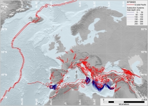 The European Fault-Source Model 2020 (EFSM20) was initially compiled in the framework of the EU Project SERA, Work Package 25, JRA3. EFSM20 includes only faults deemed capable of generating earthquakes of magnitude equal to or larger than 5.5 and aims at ...