Visualizza questa pagina nel portale RNDT
Information on Metadata
-
File Identifier: r_vda:02310-META:20160908:170950
-
Metadata Language: Italian
-
Metadata Character Set utf8
-
Parent ID: r_vda:02310-META:20160908:170950
-
Hierarchy level: Dataset
-
???catalog.mdParam.rndt.general.hierarchyLevelName Dataset
-
Metadata Responsibile:
-
Organization name: RAVDA - Ufficio Cartografico
-
Role: Point Of Contact
-
Contact Info:
-
Phone: 0165 272501
-
E-mail: u-cartografia@regione.vda.it
-
Website: https://www.regione.vda.it
-
Metadata Date Stamp: 2022-02-16
-
Standard name: Linee Guida RNDT
-
Standard version: 2.0
Reference System Information
-
Reference System Information: ED50-UTM32N
Data information
-
Identifier: r_vda:02310-DATA
-
Series ID: r_vda:02310-DATA
-
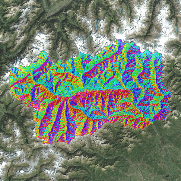
Abstract: La mappa, realizzata utilizzando il Modello digitale del terreno a passo 10 metri (derivato dal DTM passo 2 metri aggregato 2005/2008) riporta l’orientamento rispetto ai punti cardinali di tutti i versanti del territorio regionale. Il risultato è una cartografia in cui ad ogni colore corrisponde una differente esposizione rispetto al Nord. L’esposizione di un versante indica la direzione verso cui guarda un pendio, fattore che determina variazioni di esposizione alla luce solare e ai venti che sono le condizioni che determinano la temperatura e l’umidità del suolo.
-
Language: Italian
-
Character set: UTF-8, 8-bit variable size UCS Transfer Format
-
Thumbnail:
-
-
-
???catalog.schedaMetadati.thumbnail.url: https://metadati.partout.it/metadata_images/DTM_Esposizione.jpg
-
???catalog.schedaMetadati.thumbnail.type: jpg
-
???catalog.schedaMetadati.thumbnail.description: large_thumbnail
-
Information:
-
Title: Modello digitale del terreno: Carte derivate - Esposizione di versante
-
Date:
-
-
Date 2005-01-01
-
Date Type Creation Date
-
Date:
-
-
Date 2021-10-01
-
Date Type Publication Date
-
Date:
-
-
Date 2022-02-16
-
Date Type Revision Date
-
Resource responsible:
-
Organization name: Regione Autonoma Valle d'Aosta
-
Role: Owner
-
Contact Info:
-
Phone: 0165 272501
-
E-mail: u-cartografia@regione.vda.it
-
Website: https://geoportale.regione.vda.it/
-
Contact point:
-
-
Organization name: RAVDA - Ufficio cartografico
-
Role: Point Of Contact
-
Contact Info:
-
Phone: 0165 272501
-
E-mail: u-cartografia@regione.vda.it
-
Website: https://geoportale.regione.vda.it/
-
Presentation format: modelDigital
-
Update frequency: Not planned
-
Type of spatial representation: Vectorial data
-
Equivalent Scale: 1: 100
-
ISO topic categories:
- elevation
- geoscientific Information
-
Keywords:
-
-
Keyword: Elementi geografici meteorologici
-
Keyword: Elevazione
-
Thesaurus:
-
Title: GEMET - INSPIRE themes, version 1.0
-
Date:
-
-
Date 2008-06-01
-
Date Type Publication Date
-
Keyword: grid
-
Keyword: DTM
-
Thesaurus:
-
Title: GEMET - Concepts, version 2.4
-
Date:
-
-
Date 2019-01-28
-
Date Type Publication Date
-
Keyword: Regionale
-
Thesaurus:
-
Title: Spatial scope
-
Date:
-
-
Date 2019-05-22
-
Date Type Publication Date
-
Keyword: EU
-
Geographical area:
-
-
West Bounding Longitude 6.7979
-
East Bounding Longitude 7.9459
-
North Bounding Latitude 45.9932
-
South Bounding Latitude 45.4583
-
Temporal Extent:
-
-
Begin Date 2012-01-01
-
End Date 2030-12-31
-
Legal Constraints:
-
-
Access Contraints:
-
Other Constraints:
-
Legal Constraints:
-
-
Usage Constraints: Other Restrictions
-
Other Constraints: https://metadati.partout.it/metadata_documents/CC_BY_carte_derivate_DTM.pdf
Distribution
-
Distribution Format:
-
-
Format Name geo+json
-
Format Version 1.0
-
Transfer Options:
-
-
URL: https://mappe.partout.it/pub/GeoNavSCT/?metadato=MTD85N2176
-
Transfer Options:
-
-
URL: https://geoportale.regione.vda.it/download/carte-derivate
-
Distributor:
-
-
Distributor Contact:
-
-
Organization name: Ufficio Cartografico - Centro Diffusione Conoscenze Territoriali
-
Role: Distributor
-
Contact Info:
-
Phone: 0165 272501
-
E-mail: u-cartografia@regione.vda.it
-
Website: https://geoportale.regione.vda.it/
Quality
-
Quality level: Dataset
-
Conformity:
-
-
Conformity Level: Not evaluated
-
Description: Fare riferimento alle specifiche indicate
-
Conformity:
-
-
Title: REGOLAMENTO (UE) N. 1089/2010 DELLA COMMISSIONE del 23 novembre 2010 recante attuazione della direttiva 2007/2/CE del Parlamento europeo e del Consiglio per quanto riguarda l'interoperabilità dei set di dati territoriali e dei servizi di dati territoriali
-
Date:
-
-
Date 2010-12-08
-
Date Type Publication Date
-
Positional accuracy:
-
-
Value: m 0.50 m
-
Lineage: Il dato è stato ricavato dal Modello Digitale del Terreno, ottenuto da rilievo laser scanner a passo 10 metri (Modello Digitale del Terreno realizzato degradando a passo 10 metri il Modello Digitale del Terreno aggregato 2005/2008 a passo 2 metri).