Visualizza questa pagina nel portale RNDT
Information on Metadata
-
File Identifier: r_liguri:D.2191
-
Metadata Language: Italian
-
Metadata Character Set
utf8
-
Hierarchy level: Dataset
-
Metadata Responsibile:
-
Organization name: Regione Liguria - Sportello Cartografico
-
Role: Point Of Contact
-
Contact Info:
-
E-mail:
infoter@regione.liguria.it
-
Website: https://geoportal.regione.liguria.it
-
Metadata Date Stamp: 2023-12-20
-
Standard name: Linee guida RNDT
-
Standard version: 2.0
Reference System Information
-
Reference System Information: Monte-Mario-Italy1
Data information
-
Identifier: r_liguri:D.2191
-
Codespace/DOI: https://geoportal.regione.liguria.it
-
Series ID: r_liguri:D.2191
-
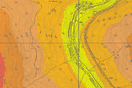
Abstract: Le fasce altimetriche descrivono l'intervallo di quota dal livello del mare alla massima elevazione del territorio. Per esigenze di rappresentazione in legenda gli intervalli sono stati raggruppati ogni 100 m. mentre quelli reali sono di 25 m. Per ogni classe di altimetria sono indicati i valori di quota minima e massima - Copertura: Provincia di La Spezia, Provincia di Genova - Lotto Levante e Lotto Centrale Blocco 1.- Origine: Elaborazione dei dati provenienti dal Modello Digitale del Terreno, ottenuto dagli elementi del "DB Geotopografico National Core sc.1:5000 (NC5) - III Edizione 3D - dal 2017"per la Provincia di La Spezia, per la Provincia di Genova - Lotto Levante e Lotto Centrale Blocco 1, ricampionato a 10 m. - Anno: 2023.
-
Language: Italian
-
Character set: UTF-8, 8-bit variable size UCS Transfer Format
-
Thumbnail:
-
-
-
???catalog.schedaMetadati.thumbnail.url: https://srvcarto.regione.liguria.it/repertoriocartografico/images/sit/STR_FASCE-ALTIM_DTM.GIF
-
Information:
-
Title: Fasce altimetriche - sc. 1:10000 - Edizione dal 2017
-
Date:
-
-
Date 2023-01-01
-
Date Type Revision Date
-
Resource responsible:
-
Organization name: Regione Liguria
-
Role: Owner
-
Contact Info:
-
E-mail:
infoter@regione.liguria.it
-
Website: https://geoportal.regione.liguria.it
-
Organization name: Regione Liguria - Informatica - Vice Direzione Generale
Presidenza
-
Role: Author
-
Contact Info:
-
E-mail:
infoter@regione.liguria.it
-
Website: https://geoportal.regione.liguria.it
-
Contact point:
-
-
Organization name: Regione Liguria - Sportello cartografico
-
Role: Point Of Contact
-
Contact Info:
-
E-mail:
infoter@regione.liguria.it
-
Website: https://geoportal.regione.liguria.it
-
Presentation format: mapDigital
-
Type of spatial representation: Vectorial data
-
Equivalent Scale: 1:
10000
-
ISO topic categories:
- elevation
-
Keywords:
-
-
Keyword: Regionale
-
Thesaurus:
-
Title: Spatial scope
-
Date:
-
-
Date 2019-05-22
-
Date Type Publication Date
-
Keyword: Elevation
-
Thesaurus:
-
Title: GEMET - INSPIRE themes, version 1.0
-
Date:
-
-
Date 2008-06-01
-
Date Type Publication Date
-
Keyword: CARTE DI BASE
-
Keyword: QUOTE E PRODOTTI DERIVATI
-
Keyword: open data
-
Keyword: EU
-
Geographical area:
-
-
West Bounding Longitude 7.48820862370018
-
East Bounding Longitude 10.0879518636137
-
North Bounding Latitude 44.849579861466
-
South Bounding Latitude 43.5963597132668
-
Other details and supplemental information:
-
Vedi documentazione all'indirizzo: https://srvcarto.regione.liguria.it/repertoriocartografico/documentazione/Copertura.pdf
-
Legal Constraints:
-
-
Access Contraints:
-
Other Constraints:
-
Legal Constraints:
-
-
Usage Constraints: Other Restrictions
-
Other Constraints:
-
Security Constraints:
-
-
Classification: unclassified
Distribution
-
Distribution Format:
-
-
Format Name
Mapinfo
-
Format Version
n.d.
-
Distribution Format:
-
-
Format Name
GeoPackage
-
Format Version
n.d.
-
Distribution Format:
-
-
Format Name
GML versione 2
-
Format Version
n.d.
-
Distribution Format:
-
-
Format Name
Shapefile
-
Format Version
n.d.
-
Distribution Format:
-
-
Format Name
GML versione 3
-
Format Version
n.d.
-
Distribution Format:
-
-
Format Name
KML
-
Format Version
n.d.
-
Transfer Options:
-
-
URL: https://srvcarto.regione.liguria.it/geoservices/apps/viewer/pages/apps/download/index.html?id=2191
-
Transfer Options:
-
-
URL: https://geoservizi.regione.liguria.it/geoserver/M2191/wfs?version=2.0.0&request=getcapabilities
-
Transfer Options:
-
-
URL: https://geoservizi.regione.liguria.it/geoserver/M2191/wms?version=1.3.0&request=getcapabilities
-
Distributor:
-
-
Distributor Contact:
-
-
Organization name: Regione Liguria - Sportello cartografico
-
Role: Distributor
-
Contact Info:
-
E-mail:
infoter@regione.liguria.it
-
Website: https://geoportal.regione.liguria.it
Quality
-
Quality level: Dataset
-
Conformity:
-
-
Conformity Level: false
-
Description: Fare riferimento alle specifiche indicate
-
Conformity:
-
-
Title: REGOLAMENTO (UE) N. 1089/2010 DELLA COMMISSIONE del 23 novembre 2010 recante attuazione della direttiva 2007/2/CE del Parlamento europeo e del Consiglio per quanto riguarda l'interoperabilità dei set di dati territoriali e dei servizi di dati territoriali
-
Date:
-
-
Date 2010-12-08
-
Date Type Publication Date
-
Positional accuracy:
-
-
Value:
m
2
m
-
Lineage: Elaborazione dei dati provenienti dal Modello Digitale del Terreno, ottenuto dagli elementi del "DB Geotopografico National Core sc.1:5000 (NC5) - III Edizione 3D - dal 2017"per la Provincia di La Spezia, per la Provincia di Genova - Lotto Levante e Lotto Centrale Blocco 1 ricampionato a 10 m.