Visualizza questa pagina nel portale RNDT
Information on Metadata
-
File Identifier: r_liguri:D.1613
-
Metadata Language: Italian
-
Metadata Character Set
utf8
-
Hierarchy level: Dataset
-
Metadata Responsibile:
-
Organization name: Regione Liguria - Sportello Cartografico
-
Role: Point Of Contact
-
Contact Info:
-
E-mail:
infoter@regione.liguria.it
-
Website: https://geoportal.regione.liguria.it
-
Metadata Date Stamp: 2022-05-19
-
Standard name: Linee guida RNDT
-
Standard version: 2.0
Reference System Information
-
Reference System Information: Monte-Mario-Italy1
Data information
-
Identifier: r_liguri:D.1613
-
Codespace/DOI: https://geoportal.regione.liguria.it
-
Series ID: r_liguri:D.1613
-
Abstract: E' rappresentata la classificazione dello Stato Chimico e dello Stato Ecologico definita in base agli esiti del monitoraggio del triennio 2009-2011, per i corpi idrici tipizzati superficiali ai sensi del DM 131/2008.
I corpi idrici sono intesi come fiumi, laghi, acque di transizione e tratti di mare.
Le classi dello stato ecologico possono corrispondere ad un livello di qualità elevato, buono, sufficiente, scarso, cattivo; invece, per quanto attiene allo stato chimico, le classi corrispondono ad un livello di qualità buono o non buono.
Il corpo idrico è definito come una "coerente sotto-unità di un bacino idrografico o di un distretto idrografico" alla quale sia possibile assegnare l'obiettivo ambientale previsto dalla Direttiva 2000/60/CE.
-
Language: Italian
-
Character set: UTF-8, 8-bit variable size UCS Transfer Format
-
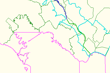
Thumbnail:
-
-
-
???catalog.schedaMetadati.thumbnail.url: https://srvcarto.regione.liguria.it/repertoriocartografico/images/sit/STR_CARATTERIZZAZIONE_ACQUE.GIF
-
Information:
-
Title: Classificazione dello Stato dei Corpi Idrici Superficiali Triennio 2009-2011 - DGR n.1615/2012
-
Date:
-
-
Date 2011-01-01
-
Date Type Revision Date
-
Resource responsible:
-
Organization name: Regione Liguria
-
Role: Owner
-
Contact Info:
-
E-mail:
ilaria.fasce@regione.liguria.it
-
Website: https://geoportal.regione.liguria.it
-
Organization name: Regione Liguria - SETTORE ECOSISTEMA COSTIERO E ACQUE - Dipartimento Ambiente e Protezione civile
-
Role: Author
-
Contact Info:
-
E-mail:
ilaria.fasce@regione.liguria.it
-
Website: https://geoportal.regione.liguria.it
-
Contact point:
-
-
Organization name: Regione Liguria - Sportello cartografico
-
Role: Point Of Contact
-
Contact Info:
-
E-mail:
infoter@regione.liguria.it
-
Website: https://geoportal.regione.liguria.it
-
Presentation format: mapDigital
-
Type of spatial representation: Vectorial data
-
Equivalent Scale: 1:
10000
-
ISO topic categories:
- inland Waters
-
Keywords:
-
-
Keyword: Regionale
-
Thesaurus:
-
Title: Spatial scope
-
Date:
-
-
Date 2019-05-22
-
Date Type Publication Date
-
Keyword: Hydrography
-
Thesaurus:
-
Title: GEMET - INSPIRE themes, version 1.0
-
Date:
-
-
Date 2008-06-01
-
Date Type Publication Date
-
Keyword: CARTE TEMATICHE
-
Keyword: ACQUE INTERNE
-
Keyword: open data
-
Keyword: EU
-
Geographical area:
-
-
West Bounding Longitude 7.48820862370018
-
East Bounding Longitude 10.0879518636137
-
North Bounding Latitude 44.849579861466
-
South Bounding Latitude 43.5963597132668
-
Legal Constraints:
-
-
Access Contraints:
-
Other Constraints:
-
Legal Constraints:
-
-
Usage Constraints: Other Restrictions
-
Other Constraints:
-
Security Constraints:
-
-
Classification: unclassified
Distribution
-
Distribution Format:
-
-
Format Name
GML versione 2
-
Format Version
n.d.
-
Distribution Format:
-
-
Format Name
GML versione 3
-
Format Version
n.d.
-
Distribution Format:
-
-
Format Name
GeoPackage
-
Format Version
n.d.
-
Distribution Format:
-
-
Format Name
Shapefile
-
Format Version
n.d.
-
Distribution Format:
-
-
Format Name
KML
-
Format Version
n.d.
-
Distribution Format:
-
-
Format Name
Mapinfo
-
Format Version
n.d.
-
Transfer Options:
-
-
URL: https://geoservizi.regione.liguria.it/geoserver/M1613/wms?version=1.3.0&request=getcapabilities
-
Transfer Options:
-
-
URL: https://srvcarto.regione.liguria.it/geoservices/apps/viewer/pages/apps/download/index.html?id=1613
-
Transfer Options:
-
-
URL: https://geoservizi.regione.liguria.it/geoserver/M1613/wfs?version=2.0.0&request=getcapabilities
-
Distributor:
-
-
Distributor Contact:
-
-
Organization name: Regione Liguria - Sportello cartografico
-
Role: Distributor
-
Contact Info:
-
E-mail:
infoter@regione.liguria.it
-
Website: https://geoportal.regione.liguria.it
Quality
-
Quality level: Dataset
-
Conformity:
-
-
Conformity Level: false
-
Description: Fare riferimento alle specifiche indicate
-
Conformity:
-
-
Title: REGOLAMENTO (UE) N. 1089/2010 DELLA COMMISSIONE del 23 novembre 2010 recante attuazione della direttiva 2007/2/CE del Parlamento europeo e del Consiglio per quanto riguarda l'interoperabilità dei set di dati territoriali e dei servizi di dati territoriali
-
Date:
-
-
Date 2010-12-08
-
Date Type Publication Date
-
Positional accuracy:
-
-
Value:
m
2
m
-
Lineage: Localizzazione su CTR