Visualizza questa pagina nel portale RNDT
Information on Metadata
-
File Identifier: r_liguri:D.1200
-
Metadata Language: Italian
-
Metadata Character Set
utf8
-
Hierarchy level: Dataset
-
Metadata Responsibile:
-
Organization name: Regione Liguria - Sportello Cartografico
-
Role: Point Of Contact
-
Contact Info:
-
E-mail:
infoter@regione.liguria.it
-
Website: https://geoportal.regione.liguria.it
-
Metadata Date Stamp: 2022-05-19
-
Standard name: Linee guida RNDT
-
Standard version: 2.0
Reference System Information
-
Reference System Information: Monte-Mario-Italy1
Data information
-
Identifier: r_liguri:D.1200
-
Codespace/DOI: https://geoportal.regione.liguria.it
-
Series ID: r_liguri:D.1200
-
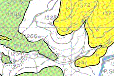
Abstract: Pietre verdi è un termine di uso comune con il quale si identificano le ofioliti, rocce magmatiche e metamorfiche, suscettibili di contenere minerali di amianto. Il dataset deriva dall'estrapolazione dei dati ufficiali dei più recenti rilevamenti geologici realizzati nell'ambito di progetti nazionali e regionali come i progetti CARG e CGR. La mappatura, a scala 1:25000, già pubblicata dal 2008 nel repertorio cartografico, è stata aggiornata con i nuovi rilievi geologici del foglio Spigno Monferrato.
Costituisce un livello conoscitivo per la gestione e l'utilizzo delle terre e rocce da scavo ed inoltre contiene l'indicazione della specifica litologia del substrato roccioso.
- Copertura: Provincie di Savona, Genova, La Spezia - Origine: Digitalizzazione da carte geologiche CARG e CGR
-
Language: Italian
-
Character set: UTF-8, 8-bit variable size UCS Transfer Format
-
Thumbnail:
-
-
-
???catalog.schedaMetadati.thumbnail.url: https://srvcarto.regione.liguria.it/repertoriocartografico/images/sit/STR_PIETREVERDI.GIF
-
Information:
-
Title: Pietre Verdi
-
Date:
-
-
Date 2013-01-01
-
Date Type Revision Date
-
Resource responsible:
-
Organization name: Regione Liguria
-
Role: Owner
-
Contact Info:
-
E-mail:
assetto.territorio@regione.liguria.it
-
Website: https://geoportal.regione.liguria.it
-
Organization name: Regione Liguria - SETTORE ASSETTO DEL TERRITORIO - Dipartimento Ambiente e Protezione civile
-
Role: Author
-
Contact Info:
-
E-mail:
assetto.territorio@regione.liguria.it
-
Website: https://geoportal.regione.liguria.it
-
Contact point:
-
-
Organization name: Regione Liguria - Sportello cartografico
-
Role: Point Of Contact
-
Contact Info:
-
E-mail:
infoter@regione.liguria.it
-
Website: https://geoportal.regione.liguria.it
-
Presentation format: mapDigital
-
Type of spatial representation: Vectorial data
-
Equivalent Scale: 1:
25000
-
ISO topic categories:
- geoscientific Information
-
Keywords:
-
-
Keyword: Regionale
-
Thesaurus:
-
Title: Spatial scope
-
Date:
-
-
Date 2019-05-22
-
Date Type Publication Date
-
Keyword: Area management/restriction/regulation zones and reporting units
-
Thesaurus:
-
Title: GEMET - INSPIRE themes, version 1.0
-
Date:
-
-
Date 2008-06-01
-
Date Type Publication Date
-
Keyword: CARTE TEMATICHE
-
Keyword: INFORMAZIONI GEOSCIENTIFICHE
-
Keyword: open data
-
Keyword: EU
-
Geographical area:
-
-
West Bounding Longitude 7.48820862370018
-
East Bounding Longitude 10.0879518636137
-
North Bounding Latitude 44.849579861466
-
South Bounding Latitude 43.5963597132668
-
Legal Constraints:
-
-
Access Contraints:
-
Other Constraints:
-
Legal Constraints:
-
-
Usage Constraints: Other Restrictions
-
Other Constraints:
-
Security Constraints:
-
-
Classification: unclassified
Distribution
-
Distribution Format:
-
-
Format Name
GML versione 3
-
Format Version
n.d.
-
Distribution Format:
-
-
Format Name
GML versione 2
-
Format Version
n.d.
-
Distribution Format:
-
-
Format Name
Mapinfo
-
Format Version
n.d.
-
Distribution Format:
-
-
Format Name
Shapefile
-
Format Version
n.d.
-
Distribution Format:
-
-
Format Name
GeoPackage
-
Format Version
n.d.
-
Distribution Format:
-
-
Format Name
KML
-
Format Version
n.d.
-
Transfer Options:
-
-
URL: https://geoservizi.regione.liguria.it/geoserver/M1200/wms?version=1.3.0&request=getcapabilities
-
Transfer Options:
-
-
URL: https://srvcarto.regione.liguria.it/geoservices/apps/viewer/pages/apps/download/index.html?id=1200
-
Transfer Options:
-
-
URL: https://geoservizi.regione.liguria.it/geoserver/M1200/wfs?version=2.0.0&request=getcapabilities
-
Distributor:
-
-
Distributor Contact:
-
-
Organization name: Regione Liguria - Sportello cartografico
-
Role: Distributor
-
Contact Info:
-
E-mail:
infoter@regione.liguria.it
-
Website: https://geoportal.regione.liguria.it
Quality
-
Quality level: Dataset
-
Conformity:
-
-
Conformity Level: false
-
Description: Fare riferimento alle specifiche indicate
-
Conformity:
-
-
Title: REGOLAMENTO (UE) N. 1089/2010 DELLA COMMISSIONE del 23 novembre 2010 recante attuazione della direttiva 2007/2/CE del Parlamento europeo e del Consiglio per quanto riguarda l'interoperabilità dei set di dati territoriali e dei servizi di dati territoriali
-
Date:
-
-
Date 2010-12-08
-
Date Type Publication Date
-
Positional accuracy:
-
-
Value:
m
5
m
-
Lineage: Digitalizzazione da carte geologiche CARG e CGR