Visualizza questa pagina nel portale RNDT
Information on Metadata
-
File Identifier: r_emiro:2013-09-18T181314
-
Metadata Language: Italian
-
Metadata Character Set UTF8
-
Parent ID: r_emiro:GXFFO
-
Hierarchy level: Dataset
-
Metadata Responsibile:
-
Individual Name: Alberto Martini
-
Organization name: Alberto Martini - Area Geologia, Suoli e Sismica - Settore Difesa del Territorio - Regione Emilia-Romagna
-
Role: Point Of Contact
-
Contact Info:
-
Phone: 0515274556
-
Fax: 0515274208
-
Delivery Point: Viale della Fiera, 8
-
City: Bologna
-
Postal Code: 40127
-
Country: ITA
-
E-mail: alberto.martini@regione.emilia-romagna.it
-
Website: http://ambiente.regione.emilia-romagna.it/geologia
-
Metadata Date Stamp: 2013-09-18
-
Standard name: Linee Guida RNDT
-
Standard version: 2.0
Reference System Information
-
Reference System Information: Monte Mario / TM Emilia-Romagna
Data information
-
Identifier: r_emiro:2013-09-18T181314
-
Series ID: r_emiro:2013-09-18T183038
-
Abstract: Modello digitale del Terreno in formato griglia che rappresenta la distribuzione dell'altimetria attraverso celle regolari a cui è associata l'informazione della quota. Il modello è derivato dalle informazioni altimetriche ricavate dalla Carta Tecnica Regionale alla scala 1:5000 (isoipse e punti quotati) integrate da dati altimetrici provenienti da rilevamenti topografici locali.
-
Purpose: Ottenere un supporto per rappresentazioni grafiche, ma soprattutto una base dati di riferimento per analisi spaziali, morfologiche e morfometriche e per interpretazioni geomorfologiche del territorio. Utile associato ad altri dati geologici e geografici digitali.
-
Language: Italian
-
Character set: UTF-8, 8-bit variable size UCS Transfer Format
-
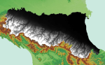
Thumbnail:
-
-
-
???catalog.schedaMetadati.thumbnail.url: http://geo.regione.emilia-romagna.it/geocatalogo/getThumbnail.jsp?layer=BASE_USER.BASE_GDS_DTM100M_RER
-
???catalog.schedaMetadati.thumbnail.type: PNG
-
???catalog.schedaMetadati.thumbnail.description: n.d.
-
Information:
-
Title: Modello Digitale del Terreno - RER (SGSS) - DTM (cella di 100m)
-
Date:
-
-
Date 2007-01-01
-
Date Type Publication Date
-
Resource responsible:
-
Individual Name: Alberto Martini
-
Organization name: Alberto Martini - Area Geologia, Suoli e Sismica - Settore Difesa del Territorio - Regione Emilia-Romagna
-
Role: Author
-
Contact Info:
-
Phone: 0515274556
-
Fax: 0515274208
-
Delivery Point: Viale della Fiera, 8
-
City: Bologna
-
Postal Code: 40127
-
Country: ITA
-
E-mail: alberto.martini@regione.emilia-romagna.it
-
Website: http://ambiente.regione.emilia-romagna.it/geologia
-
Individual Name: Raffaele Pignone (in pensione)
-
Organization name: Servizio Geologico Sismico e dei Suoli - Regione Emilia-Romagna
-
Role: Custodian
-
Contact Info:
-
Phone: 0515274792
-
Fax: 0515274208
-
Delivery Point: Viale della Fiera 8
-
City: Bologna
-
Administrative Area: BO
-
Postal Code: 40127
-
Country: ITA
-
E-mail: segrgeol@regione.emilia-romagna.it
-
Website: http://ambiente.regione.emilia-romagna.it/geologia/
-
Individual Name: Regione Emilia-Romagna
-
Organization name: Regione Emilia-Romagna
-
Role: Owner
-
Contact Info:
-
Phone: 051 5271
-
Delivery Point: Via Aldo Moro, 52
-
City: Bologna
-
Administrative Area: Regione
-
Postal Code: 40127
-
Country: ITA
-
E-mail: n.d.
-
Website: http://www.regione.emilia-romagna.it
-
Contact point:
-
-
Individual Name: Alberto Martini
-
Organization name: Alberto Martini - Area Geologia, Suoli e Sismica - Settore Difesa del Territorio - Regione Emilia-Romagna
-
Role: Point Of Contact
-
Contact Info:
-
Phone: 0515274556
-
Fax: 0515274208
-
Delivery Point: Viale della Fiera, 8
-
City: Bologna
-
Postal Code: 40127
-
Country: ITA
-
E-mail: alberto.martini@regione.emilia-romagna.it
-
Website: http://ambiente.regione.emilia-romagna.it/geologia
-
Presentation format: modelDigital
-
Update frequency: Not planned
-
Type of spatial representation: Raster data
-
Equivalent Scale: 1: 50000
-
ISO topic categories:
- elevation
- geoscientific Information
- imagery BaseMaps EarthCover
-
Keywords:
-
-
Keyword: altimetria
-
Keyword: carta di base
-
Keyword: clivometrica
-
Keyword: dsm
-
Keyword: dtm
-
Keyword: EU
-
Keyword: fotointerpretazione
-
Keyword: morfologia del territorio
-
Keyword: morfologica
-
Keyword: Regionale
-
Keyword: territorio
-
Keyword: topografia
-
Thesaurus:
-
Title: Regione
-
Date:
-
-
Date 2006-01-01
-
Date Type Publication Date
-
Keyword: cartografia
-
Keyword: geomorfologia
-
Thesaurus:
-
Title: GEMET - Concepts, version 3.1
-
Date:
-
-
Date 2012-07-20
-
Date Type Publication Date
-
Keyword: Elevazione
-
Thesaurus:
-
Title: GEMET - INSPIRE themes, version 1.0
-
Date:
-
-
Date 2008-06-01
-
Date Type Publication Date
-
Geographical area:
-
-
West Bounding Longitude 9.172921
-
East Bounding Longitude 12.850398
-
North Bounding Latitude 45.169558
-
South Bounding Latitude 43.703388
-
Temporal Extent:
-
-
Begin Date 1972-01-01
-
End Date 1979-12-31
-
Use Limitation: Utilizzo ristretto dei dati (eventuali altre informazioni nell'attributo 'altri vincoli') https://geoportale.regione.emilia-romagna.it/approfondimenti/licenze/utilizzo-ristretto-dei-dati
-
Legal Constraints:
-
-
Access Contraints:
-
Other Constraints:
-
Legal Constraints:
-
-
Usage Constraints: Other Restrictions
-
Other Constraints: https://geoportale.regione.emilia-romagna.it/approfondimenti/licenze/utilizzo-ristretto-dei-dati
-
Security Constraints:
-
-
Classification: restricted
Distribution
-
Distribution Format:
-
-
Format Name Raster
-
Format Version n.d.
-
Transfer Options:
-
-
URL: http://geo.regione.emilia-romagna.it/geocatalogo/
-
Distributor:
-
-
Distributor Contact:
-
-
Individual Name: Area Geologia, Suoli e Sismica - Settore Difesa del Territorio - Regione Emilia-Romagna
-
Organization name: Area Geologia, Suoli e Sismica - Settore Difesa del Territorio - Regione Emilia-Romagna
-
Role: Distributor
-
Contact Info:
-
Phone: 0515274792
-
Fax: 0515274208
-
Delivery Point: Viale della Fiera 8
-
City: Bologna
-
Postal Code: 40127
-
Country: ITA
-
E-mail: segrgeol@regione.emilia-romagna.it
-
Website: https://ambiente.regione.emilia-romagna.it/geologia/
Quality
-
Quality level: Dataset
-
Conformity:
-
-
Conformity Level: false
-
Description: Fare riferimento alle specifiche indicate
-
Conformity:
-
-
Title: REGOLAMENTO (UE) N. 1089/2010 DELLA COMMISSIONE del 23 novembre 2010 recante attuazione della direttiva 2007/2/CE del Parlamento europeo e del Consiglio per quanto riguarda l'interoperabilità dei set di dati territoriali e dei servizi di dati territoriali
-
Date:
-
-
Date 2010-12-08
-
Date Type Publication Date
-
Conformity:
-
-
Conformity Level: Not evaluated
-
Description: Fare riferimento alle specifiche indicate
-
Conformity:
-
-
Title: Derivato da DTM con cella di 5 m, utilizzando lo strumento Resample del software ArcGis 9.2 della ESRI e impostando la cella a 100 m.
-
Date:
-
-
Date 2007-01-01
-
Date Type Publication Date
-
Positional accuracy:
-
-
Value: m 100.0 m
-
Lineage: Il modello è stato ottenuto ricampionando il DTM con cella di 5 m, utilizzando lo strumento Resample del software ArcGis 9.2 della ESRI e impostando la cella a 100 m. Il mosaico ottenuto è stato infine ritagliato sul confine regionale.