Visualizza questa pagina nel portale RNDT
Information on Metadata
-
File Identifier: adbpo:ff2f8588-77b1-11ed-be28-0242c0
-
Metadata Language: Italian
-
Metadata Character Set utf8
-
Hierarchy level: Dataset
-
Metadata Responsibile:
-
Organization name: Autorità di bacino distrettuale del fiume Po
-
Position Name: Qualità acque, biodiversità e sviluppo sostenibile
-
Role: Point Of Contact
-
Contact Info:
-
E-mail: settore2_adbpo@adbpo.it
-
Website: https://webgis.adbpo.it
-
Metadata Date Stamp: 2025-03-31
-
Standard name: Linee Guida RNDT
-
Standard version: 2.0
Reference System Information
-
Reference System Information: 4326
Data information
-
Identifier: https://geodati.gov.it/resource/id/adbpo:ff2f8588-77b1-11ed-be28-0242c0
-
Series ID: https://geodati.gov.it/resource/id/adbpo:ff2f8588-77b1-11ed-be28-0242c0
-
Abstract: Rappresentazione tematica delle aree per la salvaguardia dell'uso potabile - Piano Di Gestione acque del distretto idrografico del fiume Po (PdGPo) 2021 (Distretto Po).
-
Purpose: https://pianoacque.adbpo.it/piano-di-gestione-2021/
-
Language: Italian
-
Character set: UTF-8, 8-bit variable size UCS Transfer Format
-
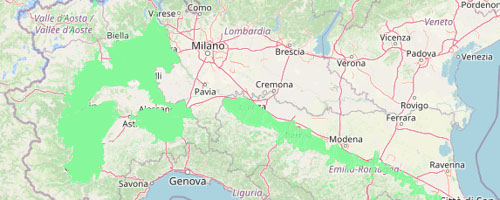
Thumbnail:
-
-
-
???catalog.schedaMetadati.thumbnail.url: https://webgis.adbpo.it/uploaded/thumbs/dataset-adbpo%3Aff2f8588-77b1-11ed-be28-0242c0-thumb-e77fab8a-0934-4f23-bbae-acf28742eb21.jpg
-
???catalog.schedaMetadati.thumbnail.type: image/png
-
???catalog.schedaMetadati.thumbnail.description: Thumbnail for 'Aree salvaguardia uso potabile PdGPo 2021 (Distretto Po)'
-
Information:
-
Title: Aree salvaguardia uso potabile PdGPo 2021 (Distretto Po)
-
Alternate Title: geonode:PdgPo2021_Aree_salvaguardia_uso_potabile
-
Date:
-
-
Date 2021-12-22
-
Date Type Creation Date
-
Resource responsible:
-
Organization name: Autorità di bacino distrettuale del fiume Po
-
Position Name: Qualità acque, biodiversità e sviluppo sostenibile
-
Role: Owner
-
Contact Info:
-
E-mail: settore2_adbpo@adbpo.it
-
Contact point:
-
-
Organization name: Autorità di bacino distrettuale del fiume Po
-
Position Name: Qualità acque, biodiversità e sviluppo sostenibile
-
Role: Point Of Contact
-
Contact Info:
-
Phone:
-
Fax:
-
Delivery Point: settore2_adbpo@adbpo.it
-
City:
-
Administrative Area:
-
Postal Code:
-
Country: ITA
-
E-mail: settore2_adbpo@adbpo.it
-
Presentation format: mapDigital
-
Update frequency: When needed
-
Type of spatial representation: Vectorial data
-
ISO topic categories:
- environment
-
Keywords:
-
-
Keyword: Regionale
-
Keyword: Siti protetti
-
Thesaurus:
-
Title: GEMET - INSPIRE themes, version 1.0
-
Date:
-
-
Date 2008-06-01
-
Date Type Publication Date
-
Keyword: Direttiva 2000/60/EC
-
Keyword: Aree di protezione di acqua potabile (Water Framework Directive)
-
Thesaurus:
-
Title: INSPIRE priority data set
-
Date:
-
-
Date 2018-04-04
-
Date Type Publication Date
-
Keyword: Regionale
-
Thesaurus:
-
Title: Spatial scope
-
Date:
-
-
Date 2019-05-22
-
Date Type Publication Date
-
Keyword: Parchi e Aree protette
-
Thesaurus:
-
Title: Registro dei dati di interesse generale per il RNDT
-
Date:
-
-
Date 2018-06-25
-
Date Type Publication Date
-
Keyword: Acque
-
Keyword: open data
-
Thesaurus:
-
Title: Parole chiave
-
Date:
-
-
Date 2021-04-20
-
Date Type Publication Date
-
Keyword: Distretto Po
-
Thesaurus:
-
Title: Bacino di riferimento
-
Date:
-
-
Date 2021-04-20
-
Date Type Publication Date
-
Keyword: Aree Protette
-
Thesaurus:
-
Title: Piano acque (PdGPo)
-
Date:
-
-
Date 2021-04-20
-
Date Type Publication Date
-
Geographical area:
-
-
West Bounding Longitude 6.561532188994952
-
East Bounding Longitude 12.873990498649093
-
North Bounding Latitude 46.44022286666229
-
South Bounding Latitude 43.639031989897
-
Temporal Extent:
-
-
Begin Date 2021-12-22T00:00:00+00:00
-
End Date 2027-12-22T00:00:00+00:00
-
Other details and supplemental information:
-
https://www.adbpo.it/PianoAcque2021/PdGPo2021_22dic21/Elaborato_00_RelGEn_22dic2021/PdGPo2021_Elab_0_RelGen_22dic21.pdf
-
Legal Constraints:
-
-
Access Contraints:
-
Other Constraints:
-
Legal Constraints:
-
-
Usage Constraints: Other Restrictions
-
Other Constraints:
Distribution
-
Distribution Format:
-
-
Format Name ESRI ShapeFile
-
Format Version 1.0
-
Transfer Options:
-
-
URL: https://webgis.adbpo.it/catalogue/#/dataset/1167
-
Transfer Options:
-
-
URL: https://webgis.adbpo.it/geoserver/ows
-
Transfer Options:
-
-
URL: https://webgis.adbpo.it/geoserver/ows
-
Distributor:
-
-
Distributor Contact:
-
-
Organization name: Autorità di bacino distrettuale del fiume Po
-
Position Name: Qualità acque, biodiversità e sviluppo sostenibile
-
Role: Point Of Contact
-
Contact Info:
-
E-mail: settore2_adbpo@adbpo.it
-
Website: https://webgis.adbpo.it
Quality
-
Quality level: Dataset
-
Conformity:
-
-
Conformity Level: true
-
Description: non valutato
-
Conformity:
-
-
Title: REGOLAMENTO (UE) N. 1089/2010 DELLA COMMISSIONE del 23 novembre 2010 recante attuazione della direttiva 2007/2/CE del Parlamento europeo e del Consiglio per quanto riguarda l'interoperabilità dei set di dati territoriali e dei servizi di dati territoriali
-
Date:
-
-
Date 2010-12-08
-
Date Type Publication Date
-
Positional accuracy:
-
-
Value: m 1300.0 m
-
Lineage: ...