Visualizza questa pagina nel portale RNDT
Information on Metadata
-
File Identifier: arpa_09:03811-META:20190724:084000
-
Metadata Language: Italian
-
Metadata Character Set utf8
-
Parent ID: arpa_09:03811-META:20190724:084000
-
Hierarchy level: Dataset
-
???catalog.mdParam.rndt.general.hierarchyLevelName Dataset
-
Metadata Responsibile:
-
Organization name: Agenzia Regionale per la Protezione dell'Ambiente della Valle D'Aosta
-
Role: Point Of Contact
-
Contact Info:
-
Phone: 0165 278511
-
E-mail: arpa@arpa.vda.it
-
Website: https://www.arpa.vda.it
-
Metadata Date Stamp: 2022-10-05
-
Standard name: Linee Guida RNDT
-
Standard version: 2.0
Reference System Information
-
Reference System Information: WGS84
Data information
-
Identifier: arpa_09:03811-DATA
-
Series ID: arpa_09:03811-DATA
-
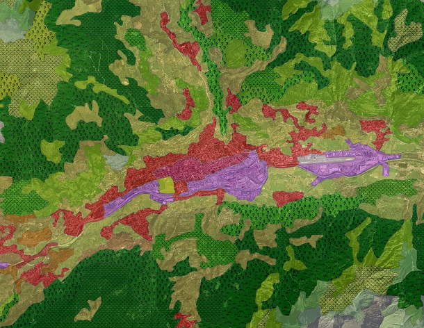
Abstract: Il CORINE Land Cover 2018 costituisce l'aggiornamento della precedente versione del Programma CORINE (Coordination of Information on the Environment) della Commissione Europea. Tale aggiornamento, coordinato dalla European Environment Agency (EEA), è gestito a livello nazionale dall'Istituto Superiore per la Protezione e la Ricerca Ambientale (ISPRA), e realizzato per la Valle d'Aosta da ARPA VdA. E' costituito da geometrie poligonali organizzate in 44 classi di copertura di suolo strutturate secondo una gerarchia a quattro livelli. La scala nominale del prodotto è 1:100.000. La scala indicativa di fotointerpretazione, basata su immagini Sentinel 2 e dati ancillari è 1:20.000 - 1:40.000. L'unità minima cartografabile è di 25 ha.
-
Language: Italian
-
Character set: UTF-8, 8-bit variable size UCS Transfer Format
-
Thumbnail:
-
-
-
???catalog.schedaMetadati.thumbnail.url: https://metadati.partout.it/metadata_images/Corine_Landcover.jpg
-
???catalog.schedaMetadati.thumbnail.type: jpg
-
???catalog.schedaMetadati.thumbnail.description: large_thumbnail
-
Information:
-
Title: Copertura Suolo: Corine Land Cover 4° livello - dato ARPA 2018
-
Date:
-
-
Date 2018-01-01
-
Date Type Creation Date
-
Date:
-
-
Date 2019-06-01
-
Date Type Publication Date
-
Date:
-
-
Date 2025-06-13
-
Date Type Revision Date
-
Resource responsible:
-
Organization name: Agenzia Regionale per la Protezione dell'Ambiente della Valle D'Aosta
-
Role: Owner
-
Contact Info:
-
Phone: 0165 278511
-
E-mail: arpa@arpa.vda.it
-
Website: http://www.arpa.vda.it
-
Contact point:
-
-
Organization name: ARPA Agenzia Regionale per la Protezione dell'Ambiente
-
Role: Point Of Contact
-
Contact Info:
-
Phone: 0165 278511
-
E-mail: arpa@arpa.vda.it
-
Website: https://www.arpa.vda.it
-
Presentation format: mapDigital
-
Update frequency: Not planned
-
Type of spatial representation: Vectorial data
-
Equivalent Scale: 1: 10000
-
ISO topic categories:
- environment
- geoscientific Information
-
Keywords:
-
-
Keyword: Copertura del suolo
-
Keyword: Utilizzo del territorio
-
Thesaurus:
-
Title: GEMET - INSPIRE themes, version 1.0
-
Date:
-
-
Date 2008-06-01
-
Date Type Publication Date
-
Keyword: Copertura del suolo
-
Keyword: Utilizzo del territorio
-
Thesaurus:
-
Title: GEMET - Concepts, version 2.4
-
Date:
-
-
Date 2019-01-28
-
Date Type Publication Date
-
Keyword: Regionale
-
Thesaurus:
-
Title: Spatial scope
-
Date:
-
-
Date 2019-05-22
-
Date Type Publication Date
-
Keyword: Copertura del suolo
-
Keyword: Utilizzo del territorio
-
Thesaurus:
-
Title: ARPA
-
Date:
-
-
Date 2017-03-02
-
Date Type Publication Date
-
Keyword: EU
-
Keyword: open data
-
Geographical area:
-
-
West Bounding Longitude 6.7979
-
East Bounding Longitude 7.9459
-
North Bounding Latitude 45.9932
-
South Bounding Latitude 45.4583
-
Temporal Extent:
-
-
Begin Date 2012
-
End Date 2018
-
Legal Constraints:
-
-
Access Contraints:
-
Other Constraints:
-
Legal Constraints:
-
-
Usage Constraints: Other Restrictions
-
Other Constraints: https://sct-outil.regione.vda.it/SCTProfessional/static/pdf/CC_BY_Repertorio_SCT_Outil_v3.pdf
Distribution
-
Distribution Format:
-
-
Format Name geo+json
-
Format Version 1.0
-
Transfer Options:
-
-
URL: https://mappe.partout.it/pub/GeoNavSCT/?metadato=MTD182N2470
-
Distributor:
-
-
Distributor Contact:
-
-
Organization name: Agenzia Regionale per la Protezione dell'Ambiente della Valle D'Aosta
-
Role: Distributor
-
Contact Info:
-
Phone: 0165 278561
-
E-mail: arpa@arpa.vda.it
-
Website: https://www.arpa.vda.it
Quality
-
Quality level: Dataset
-
Conformity:
-
-
Conformity Level: Not evaluated
-
Description: Fare riferimento alle specifiche indicate
-
Conformity:
-
-
Title: REGOLAMENTO (UE) N. 1089/2010 DELLA COMMISSIONE del 23 novembre 2010 recante attuazione della direttiva 2007/2/CE del Parlamento europeo e del Consiglio per quanto riguarda l'interoperabilità dei set di dati territoriali e dei servizi di dati territoriali
-
Date:
-
-
Date 2010-12-08
-
Date Type Publication Date
-
Positional accuracy:
-
-
Value: m 0.02 m
-
Lineage: Il CORINE Land Cover 2018 costituisce l'aggiornamento della precedente versione del Programma CORINE (Coordination of Information on the Environment) della Commissione Europea. Tale aggiornamento, coordinato dalla European Environment Agency (EEA), è gestito a livello nazionale dall'Istituto Superiore per la Protezione e la Ricerca Ambientale (ISPRA), e realizzato per la Valle d'Aosta da ARPA VdA.