Visualizza questa pagina nel portale RNDT
Information on Metadata
-
File Identifier: r_toscan:fe5bec9c-2e46-4a23-9f06-89cb9304c961
-
Metadata Language: Italian
-
Metadata Character Set utf8
-
Hierarchy level: Dataset
-
Metadata Responsibile:
-
Organization name: Regione Toscana - Settore Sistema Informativo e Pianificazione del Territorio
-
Role: Point Of Contact
-
Contact Info:
-
E-mail: contatto.cartografia@regione.toscana.it
-
Metadata Date Stamp: 2025-11-28
-
Standard name: Linee Guida RNDT
-
Standard version: 2.0
Reference System Information
-
Reference System Information: RDN2008 / UTM zone 32N
Data information
-
Identifier: r_toscan:fe5bec9c-2e46-4a23-9f06-89cb9304c961
-
Series ID: r_toscan:fe5bec9c-2e46-4a23-9f06-89cb9304c961
-
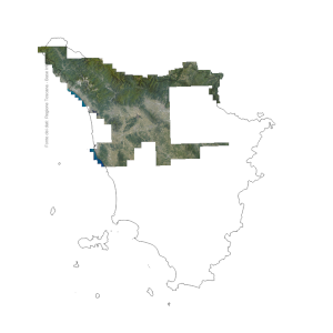
Abstract: Ortofoto digitali relative al 2025, acquisite ai sensi della legge regionale art. 55 bis comma 1 lettera b), risultato della mosaicatura di più fotogrammi di titolarità di AGEA acquisiti tra il 25 maggio e il 28 giugno 2025. Le immagini sono in formato .tif, 8bit multispettrali (RGB+NIR) con GSD pari a 20cm.Si precisa che le ortofoto sono prodotte nell’ambito delle attività di rilievo fotogrammetrico straordinario avviate a seguito degli eventi climatici eccezionali del 14 marzo 2025 che hanno colpito le zone dell’alta Toscana per cui hanno una copertura delle sole aree di interesse
-
Language: Italian
-
Character set: UTF-8, 8-bit variable size UCS Transfer Format
-
Thumbnail:
-
-
-
???catalog.schedaMetadati.thumbnail.url: https://www502.regione.toscana.it/geonetwork/srv/api/records/r_toscan:fe5bec9c-2e46-4a23-9f06-89cb9304c961/attachments/rt203%20Orto2025%20fe5.png
-
???catalog.schedaMetadati.thumbnail.description: rt203 Orto2025 fe5.png
-
Information:
-
Title: Regione Toscana - Ortofoto anno 2025 RT
-
Date:
-
-
Date 2025-10-27
-
Date Type Publication Date
-
Date:
-
-
Date 2025-09-29
-
Date Type Creation Date
-
Resource responsible:
-
Organization name: Regione Toscana
-
Role: Owner
-
Contact Info:
-
E-mail: urp@regione.toscana.it
-
Contact point:
-
-
Organization name: Regione Toscana - Settore Sistema Informativo e Pianificazione del Territorio
-
Role: Point Of Contact
-
Contact Info:
-
E-mail: contatto.cartografia@regione.toscana.it
-
Presentation format: imageDigital
-
Type of spatial representation: Raster data
-
ISO topic categories:
- imagery BaseMaps EarthCover
- planning - Cadastre
-
Keywords:
-
-
Keyword: Orto immagini
-
Thesaurus:
-
Title: GEMET - INSPIRE themes, version 1.0
-
Date:
-
-
Date 2008-06-01
-
Date Type Publication Date
-
Keyword: Ortofoto aeree
-
Thesaurus:
-
Title: Registro dei dati di interesse generale per il RNDT
-
Date:
-
-
Date 2018-06-25
-
Date Type Publication Date
-
Keyword: EU
-
Keyword: RNDT
-
Keyword: opendata
-
Keyword: High-value dataset
-
Keyword: Regionale
-
Thesaurus:
-
Title: Spatial scope
-
Date:
-
-
Date 2019-05-22
-
Date Type Publication Date
-
Keyword: fotogrammetria
-
Keyword: fotografia aerea (immagine)
-
Keyword: mosaico (immagine)
-
Thesaurus:
-
Title: GEMET
-
Date:
-
-
Date 2018-08-16
-
Date Type Publication Date
-
Keyword: Dati geospaziali
-
Thesaurus:
-
Title: High-value dataset categories
-
Date:
-
-
Date 2023-09-05
-
Date Type Publication Date
-
Geographical area:
-
-
West Bounding Longitude 9.59
-
East Bounding Longitude 12.46
-
North Bounding Latitude 44.45
-
South Bounding Latitude 42.24
-
Temporal Extent:
-
-
Begin Date 2025-05-25
-
End Date 2025-06-28
-
Other details and supplemental information:
-
Cod.RT: 203 Orto2025 fe5
-
Use Limitation: Nessuna condizione applicabile
-
Legal Constraints:
-
-
Access Contraints:
-
Other Constraints:
-
Legal Constraints:
-
-
Usage Constraints: Other Restrictions
-
Other Constraints: La risorsa è liberamente accessibile e usabile con licenza CC BY 4.0
Distribution
-
Distribution Format:
-
-
Format Name TIFF
-
Format Version 1.0
-
Transfer Options:
-
-
URL: https://www502.regione.toscana.it/geoscopio/ortofoto.html
-
Distributor:
-
-
Distributor Contact:
-
-
Organization name: Regione Toscana - Settore Sistema Informativo e Pianificazione del Territorio
-
Role: Distributor
-
Contact Info:
-
E-mail: contatto.cartografia@regione.toscana.it
Quality
-
Quality level: Dataset
-
Conformity:
-
-
Conformity Level: Not evaluated
-
Description: non valutato
-
Conformity:
-
-
Title: REGOLAMENTO (UE) N. 1089/2010 DELLA COMMISSIONE del 23 novembre 2010 recante attuazione della direttiva 2007/2/CE del Parlamento europeo e del Consiglio per quanto riguarda l'interoperabilità dei set di dati territoriali e dei servizi di dati territoriali
-
Date:
-
-
Date 2010-12-08
-
Date Type Publication Date
-
Positional accuracy:
-
-
Value: m 1 m
-
Lineage: Ortofoto realizzata a partire dai fotogrammi acquisiti da AGEA. Le ortofoto sono state poi realizzate da CGR S.P.A. secondo le prescrizioni tecniche reperibili al seguente link: https://www.regione.toscana.it/documents/10180/25238473/Prescrizioni_tecniche_orto-2022.pdf/e2b662e0-a10b-e0a9-3db1-1c2ba99575ef?t=1679486383180