Visualizza questa pagina nel portale RNDT
Information on Metadata
-
File Identifier: r_toscan:f3ff89ee-49fa-4487-89fe-c69ae58ecd0c
-
Metadata Language: Italian
-
Metadata Character Set utf8
-
Hierarchy level: Dataset
-
Metadata Responsibile:
-
Organization name: Regione Toscana - Settore Sistema Informativo e Pianificazione del Territorio
-
Role: Point Of Contact
-
Contact Info:
-
E-mail: contatto.cartografia@regione.toscana.it
-
Website:
-
Metadata Date Stamp: 2025-02-06
-
Standard name: Linee Guida RNDT
-
Standard version: 2.0
Reference System Information
-
Reference System Information: RDN2008 / UTM zone 32N
Data information
-
Identifier: r_toscan:f3ff89ee-49fa-4487-89fe-c69ae58ecd0c
-
Series ID: r_toscan:f3ff89ee-49fa-4487-89fe-c69ae58ecd0c
-
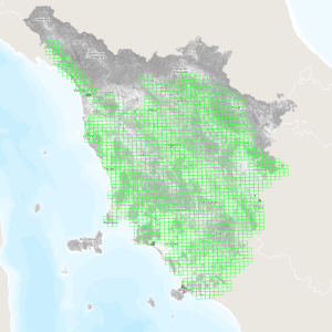
Abstract: Quadro di unione (Elementi 1:5000) di dati in formato raster con risoluzione 1x1 m (DTM e DSM) relativi a rilievi LiDAR eseguiti negli anni 2019, 2020 e 2021.Il sistema di riferimento è quello geodetico nazionale ETRF2000 epoca 2008.0, realizzazione del sistema globale ETRS89, materializzato dalla rete RDN. La rappresentazione cartografica è quella conforme UTM (RDN2008/UTM zone 32N).La metainformazione del dato LiDAR è disponibile al seguente link https://www502.regione.toscana.it/geoscopio/geometa/html/r_toscan_261ec1b2-bf25-4973-b853-ac08e060ec62.htm
-
Language: Italian
-
Character set: UTF-8, 8-bit variable size UCS Transfer Format
-
Thumbnail:
-
-
-
???catalog.schedaMetadati.thumbnail.url: https://www502.regione.toscana.it:/geonetwork/srv/api/records/r_toscan:f3ff89ee-49fa-4487-89fe-c69ae58ecd0c/attachments/rt155%20QuLidarIRS%20f3f.png
-
???catalog.schedaMetadati.thumbnail.description: rt155 QuLidarIRS f3f.png
-
Information:
-
Title: Regione Toscana - Quadro di unione Lidar non di proprietà RT
-
Date:
-
-
Date 2023-10-12
-
Date Type Creation Date
-
Date:
-
-
Date 2023-10-12
-
Date Type Publication Date
-
Date:
-
-
Date 2023-10-12
-
Date Type Revision Date
-
Resource responsible:
-
Organization name: Regione Toscana
-
Role: Owner
-
Contact Info:
-
E-mail: urp@regione.toscana.it
-
Website:
-
Contact point:
-
-
Organization name: Regione Toscana - Settore Sistema Informativo e Pianificazione del Territorio
-
Role: Point Of Contact
-
Contact Info:
-
E-mail: contatto.cartografia@regione.toscana.it
-
Website:
-
Presentation format: mapDigital
-
Type of spatial representation: Vectorial data
-
Equivalent Scale: 1: 5000
-
ISO topic categories:
- imagery BaseMaps EarthCover
- geoscientific Information
-
Keywords:
-
-
Keyword: EU
-
Keyword: RNDT
-
Keyword: Elevazione
-
Thesaurus:
-
Title: GEMET - INSPIRE themes, version 1.0
-
Date:
-
-
Date 2008-06-01
-
Date Type Publication Date
-
Keyword: opendata
-
Keyword: Regionale
-
Thesaurus:
-
Title: Spatial scope
-
Date:
-
-
Date 2019-05-22
-
Date Type Publication Date
-
Keyword: modello digitale del territorio
-
Keyword: informazione geo-referenziata
-
Thesaurus:
-
Title: GEMET
-
Date:
-
-
Date 2018-08-16
-
Date Type Publication Date
-
Keyword:
-
Thesaurus:
-
Title: Tipo di servizio di dati territoriali
-
Date:
-
-
Date 2021-09-23T12:52:17
-
Date Type Publication Date
-
Keyword:
-
Thesaurus:
-
Title: Conditions Applying To Access and Use
-
Date:
-
-
Date 2020-10-30
-
Date Type Publication Date
-
Keyword: no limitations to public access
-
Thesaurus:
-
Title: Limitations on public access
-
Date:
-
-
Date 2020-10-22
-
Date Type Publication Date
-
Geographical area:
-
-
West Bounding Longitude 9.59
-
East Bounding Longitude 12.46
-
North Bounding Latitude 44.45
-
South Bounding Latitude 42.24
-
Other details and supplemental information:
-
Cod.RT: 155 - QuLidarIRS - f3f
-
Use Limitation: no conditions apply
-
Legal Constraints:
-
-
Access Contraints:
-
Other Constraints:
-
Legal Constraints:
-
-
Usage Constraints: Other Restrictions
-
Other Constraints: La risorsa è liberamente accessibile e usabile con licenza CC BY
Distribution
-
Distribution Format:
-
-
Format Name ESRI Shapefile
-
Format Version 1.0
-
Transfer Options:
-
-
URL: https://www502.regione.toscana.it/geoscopio/cartoteca.html
-
Distributor:
-
-
Distributor Contact:
-
-
Organization name: Regione Toscana - Settore Sistema Informativo e Pianificazione del Territorio
-
Role: Distributor
-
Contact Info:
-
E-mail: contatto.cartografia@regione.toscana.it
-
Website:
Quality
-
Quality level: Dataset
-
Conformity:
-
-
Conformity Level: Not evaluated
-
Description: Fare riferimento alle specifiche indicate
-
Conformity:
-
-
Title: REGOLAMENTO (UE) N. 1089/2010 DELLA COMMISSIONE del 23 novembre 2010 recante attuazione della direttiva 2007/2/CE del Parlamento europeo e del Consiglio per quanto riguarda l'interoperabilità dei set di dati territoriali e dei servizi di dati territoriali
-
Date:
-
-
Date 2010-12-08
-
Date Type Publication Date
-
Positional accuracy:
-
-
Value: m 1 m
-
Lineage: Il taglio cartografico è il bounding box, nella proiezione indicata, dell’Elemento quale sessantaquattresima parte del foglio alla scala 1:50.000 nell’inquadramento ED50.