Visualizza questa pagina nel portale RNDT
Information on Metadata
-
File Identifier: r_toscan:f28fdf59-8158-4fab-9733-d897939d93a8
-
Metadata Language: Italian
-
Metadata Character Set utf8
-
Hierarchy level: Dataset
-
Metadata Responsibile:
-
Organization name: Regione Toscana - Settore Sistema Informativo e Pianificazione del Territorio
-
Role: Point Of Contact
-
Contact Info:
-
E-mail: contatto.cartografia@regione.toscana.it
-
Website:
-
Metadata Date Stamp: 2025-05-09
-
Standard name: Linee Guida RNDT
-
Standard version: 2.0
Reference System Information
-
Reference System Information: Monte-Mario-Italy1
Data information
-
Identifier: r_toscan:f28fdf59-8158-4fab-9733-d897939d93a8
-
Series ID: r_toscan:f28fdf59-8158-4fab-9733-d897939d93a8
-
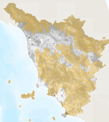
Abstract: Mappa dei territori eligibili al metodo LEADER del Programma di Sviluppo Rurale della Regione Toscana 2014-2022, come definiti dalla Delibera di Giunta regionale n. 246 del 29.03.2016.Le aree rurali eligibili al metodo LEADER sono classificate in 3 tipologie in base alla normativa sopra citata:C1. Aree rurali intermedie in transizione (eligibili solo per alcuni Comuni)C2. Aree rurali intermedie in declinoD. Aree rurali con problemi di sviluppoPer ulteriori informazioni cosultare i link https://www.regione.toscana.it/-/tipologie-di-territori-a-cui-sono-soggetti-alcuni-interventi-del-programma-di-sviluppo-rurale-2014-20 e https://www.regione.toscana.it/psr-2014-2020/leader.
-
Language: Italian
-
Character set: UTF-8, 8-bit variable size UCS Transfer Format
-
Thumbnail:
-
-
-
???catalog.schedaMetadati.thumbnail.url: https://www502.regione.toscana.it/geonetwork/srv/api/records/r_toscan:f28fdf59-8158-4fab-9733-d897939d93a8/attachments/rt121%20feasr%20leader%20f28.png
-
???catalog.schedaMetadati.thumbnail.description: rt121 feasr leader f28.png
-
Information:
-
Title: Regione Toscana - PSR Feasr 2014-2022 - Zone eligibili al metodo LEADER
-
Date:
-
-
Date 2015-01-01
-
Date Type Creation Date
-
Date:
-
-
Date 2015-01-01
-
Date Type Publication Date
-
Date:
-
-
Date 2022-07-01
-
Date Type Revision Date
-
Resource responsible:
-
Organization name: Regione Toscana
-
Role: Owner
-
Contact Info:
-
E-mail: urp@regione.toscana.it
-
Website:
-
Contact point:
-
-
Organization name: Regione Toscana - Autorità di gestione Feasr. Sostegno allo sviluppo delle attività agricole
-
Role: Point Of Contact
-
Contact Info:
-
E-mail: adgpsrfeasr@regione.toscana.it
-
Website:
-
Presentation format: mapDigital
-
Type of spatial representation: Vectorial data
-
Equivalent Scale: 1: 10000
-
ISO topic categories:
- planning - Cadastre
- farming
-
Keywords:
-
-
Keyword: EU
-
Keyword: RNDT
-
Keyword: Utilizzo del territorio
-
Keyword: Zone sottoposte a gestione/limitazioni/regolamentazione e unità con obbligo di comunicare dati
-
Thesaurus:
-
Title: GEMET - INSPIRE themes, version 1.0
-
Date:
-
-
Date 2008-06-01
-
Date Type Publication Date
-
Keyword: opendata
-
Keyword: PSR
-
Keyword: GAL
-
Keyword: FEASR
-
Keyword: LEADER
-
Keyword: Regionale
-
Thesaurus:
-
Title: Spatial scope
-
Date:
-
-
Date 2019-05-22
-
Date Type Publication Date
-
Keyword: sviluppo del territorio
-
Keyword: sviluppo economico
-
Keyword: agricoltura
-
Thesaurus:
-
Title: GEMET
-
Date:
-
-
Date 2018-08-16
-
Date Type Publication Date
-
Geographical area:
-
-
West Bounding Longitude 9.59
-
East Bounding Longitude 12.46
-
North Bounding Latitude 44.45
-
South Bounding Latitude 42.24
-
Other details and supplemental information:
-
Cod.RT: 121 - FeasrLeader - f28
-
Use Limitation: no conditions apply
-
Legal Constraints:
-
-
Access Contraints:
-
Other Constraints:
-
Legal Constraints:
-
-
Usage Constraints: Other Restrictions
-
Other Constraints: La risorsa è liberamente accessibile e usabile con licenza CC BY
Distribution
-
Distribution Format:
-
-
Format Name ESRI Shapefile
-
Format Version 1.0
-
Transfer Options:
-
-
URL: https://www502.regione.toscana.it/geoscopio/zonefeasr.html
-
Transfer Options:
-
-
URL: https://www502.regione.toscana.it/wmsraster/com.rt.wms.RTmap/wms?map=wmsambprogr&map_resolution=91&language=ita&
-
Distributor:
-
-
Distributor Contact:
-
-
Organization name: Regione Toscana - Settore Sistema Informativo e Pianificazione del Territorio
-
Role: Distributor
-
Contact Info:
-
E-mail: contatto.cartografia@regione.toscana.it
-
Website:
Quality
-
Quality level: Dataset
-
Conformity:
-
-
Conformity Level: Not evaluated
-
Description: Fare riferimento alle specifiche indicate
-
Conformity:
-
-
Title: REGOLAMENTO (UE) N. 1089/2010 DELLA COMMISSIONE del 23 novembre 2010 recante attuazione della direttiva 2007/2/CE del Parlamento europeo e del Consiglio per quanto riguarda l'interoperabilità dei set di dati territoriali e dei servizi di dati territoriali
-
Date:
-
-
Date 2010-12-08
-
Date Type Publication Date
-
Positional accuracy:
-
-
Value: m 2.5 m
-
Lineage: Le zone sono derivate dal dataset equivalente della gestione "feasr 2007-2013" aggiornato sulla base dell'eligibilità determinata dalla Delibera di Giunta regionale n. 246 del 29.03.2016. Per le aree elegibili è stato valorizzato a 1 il campo "E_LEADER".