Visualizza questa pagina nel portale RNDT
Information on Metadata
-
File Identifier: r_toscan:ad17b0db-a475-4e7b-b6d5-21eb6c520b9f
-
Metadata Language: Italian
-
Metadata Character Set utf8
-
Hierarchy level: Dataset
-
Metadata Responsibile:
-
Organization name: Regione Toscana - Settore Sistema Informativo e Pianificazione del Territorio
-
Role: Point Of Contact
-
Contact Info:
-
E-mail: contatto.cartografia@regione.toscana.it
-
Website:
-
Metadata Date Stamp: 2025-01-14
-
Standard name: Linee Guida RNDT
-
Standard version: 2.0
Reference System Information
-
Reference System Information: RND2008-TM32NE
Data information
-
Identifier: r_toscan:ad17b0db-a475-4e7b-b6d5-21eb6c520b9f
-
Series ID: r_toscan:ad17b0db-a475-4e7b-b6d5-21eb6c520b9f
-
Abstract: Assi stradali principali della rete regionale che costituiscono una delle sorgenti di rumore interessate dalla Direttiva 2002/49/CE. Gli assi stradali presenti nel dataset rappresentano un sottoinsieme dell’intera rete stradale regionale, come stabilito dal decreto legislativo 19 agosto 2005, n. 194 che identifica come “asse stradale principale” un'infrastruttura stradale su cui transitano ogni anno più di 3.000.000 di veicoli. Una piu’ approfondita relazione tecnico-descrittiva si trova all’indirizzo https://www502.regione.toscana.it/geoscopio/hotlinks/inquinamenti_fisici/mappe_acustiche/RD_IT_0026_report_2022.pdf?catIdx=2%2F0%2F2%2F1&layIdx=0&tolobbox=452470.77195006:876240.34804994:4680060:4924665.5&tolosrid=EPSG%3A25832&tolozoom=1099276.3131510108&tololayerserver=http%3A%2F%2Fwww502.regione.toscana.it%3A80%2Fwmsraster%2Fcom.rt.wms.RTmap%2Fwms%3Fmap%3Dwmssfondo%26version%3D1.3.0&tololayername=a
-
Language: Italian
-
Character set: UTF-8, 8-bit variable size UCS Transfer Format
-
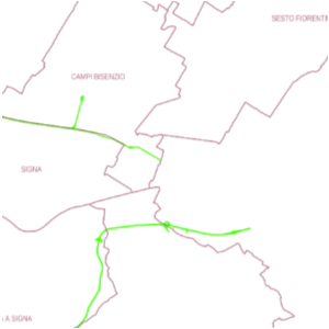
Thumbnail:
-
-
-
???catalog.schedaMetadati.thumbnail.url: https://www502.regione.toscana.it/geonetwork/srv/api/records/r_toscan:ad17b0db-a475-4e7b-b6d5-21eb6c520b9f/attachments/rt141%20MaStrAssi%20ad1%20.png
-
???catalog.schedaMetadati.thumbnail.description: rt141 MaStrAssi ad1
-
Information:
-
Title: Regione Toscana - Assi dell’infrastruttura stradale principale (DF1_5)
-
Date:
-
-
Date 2022-11-04
-
Date Type Creation Date
-
Date:
-
-
Date 2022-11-04
-
Date Type Revision Date
-
Resource responsible:
-
Organization name: Regione Toscana
-
Role: Owner
-
Contact Info:
-
E-mail: urp@regione.toscana.it
-
Website:
-
Contact point:
-
-
Organization name: Settore Viabilità regionale ambiti Arezzo, Siena e Grosseto. Programmazione risanamento acustico
-
Role: Point Of Contact
-
Contact Info:
-
E-mail: sandra.grani@regione.toscana.it
-
Website:
-
Organization name: ARPAT
-
Role: Principal Investigator
-
Contact Info:
-
Phone:
-
E-mail: urp@arpat.toscana.it
-
Website:
-
Presentation format: mapDigital
-
Type of spatial representation: Vectorial data
-
Equivalent Scale: 1: 10000
-
ISO topic categories:
- environment
- transportation
-
Keywords:
-
-
Keyword: EU
-
Keyword: RNDT
-
Keyword: Reti di trasporto
-
Keyword: Salute umana e sicurezza
-
Thesaurus:
-
Title: GEMET - INSPIRE themes, version 1.0
-
Date:
-
-
Date 2008-06-01
-
Date Type Publication Date
-
Keyword: opendata
-
Keyword: Regionale
-
Thesaurus:
-
Title: Spatial scope
-
Date:
-
-
Date 2019-05-22
-
Date Type Publication Date
-
Keyword: mappa acustica
-
Thesaurus:
-
Title: GEMET
-
Date:
-
-
Date 2018-08-16
-
Date Type Publication Date
-
Geographical area:
-
-
West Bounding Longitude 9.59
-
East Bounding Longitude 12.46
-
North Bounding Latitude 44.45
-
South Bounding Latitude 42.24
-
Temporal Extent:
-
-
Begin Date 2022-01-01
-
End Date 2022-12-31
-
Other details and supplemental information:
-
Cod.RT: 141 - MaStrAssi - ad1
-
Use Limitation: no conditions apply
-
Legal Constraints:
-
-
Access Contraints:
-
Other Constraints:
-
Legal Constraints:
-
-
Usage Constraints: Other Restrictions
-
Other Constraints: La risorsa è liberamente accessibile e usabile con licenza CC BY
Distribution
-
Distribution Format:
-
-
Format Name Geopackage
-
Format Version 1.0
-
Transfer Options:
-
-
URL: https://www502.regione.toscana.it/geoscopio/inquinamentifisici.html
-
Distributor:
-
-
Distributor Contact:
-
-
Organization name: Regione Toscana - Settore Sistema Informativo e Pianificazione del Territorio
-
Role: Distributor
-
Contact Info:
-
E-mail: contatto.cartografia@regione.toscana.it
-
Website:
Quality
-
Quality level: Dataset
-
Conformity:
-
-
Conformity Level: Not evaluated
-
Description: Fare riferimento alle specifiche indicate
-
Conformity:
-
-
Title: REGOLAMENTO (UE) N. 1089/2010 DELLA COMMISSIONE del 23 novembre 2010 recante attuazione della direttiva 2007/2/CE del Parlamento europeo e del Consiglio per quanto riguarda l'interoperabilità dei set di dati territoriali e dei servizi di dati territoriali
-
Date:
-
-
Date 2010-12-08
-
Date Type Publication Date
-
Positional accuracy:
-
-
Value: m 10 m
-
Lineage: Tratte stradali estratte dal database topografico regionale rilevato con interpretazione fotogrammetrica e rilievi a terra alla scala 1:10000. Oltre all’informazione sulla posizione data dalla geometria, nella tabella attributi del dataset vettoriale, a ciascun asse stradale sono associate proprietà specifiche, quali, tra le altre l’identificativo univoco stradale, il nome della strada, la lunghezza e il flusso di traffico annuale.