Visualizza questa pagina nel portale RNDT
Information on Metadata
-
File Identifier: r_toscan:414f8ed8-9201-43dd-999d-d5ae5b2e7764
-
Metadata Language: Italian
-
Metadata Character Set utf8
-
Hierarchy level: Dataset
-
Metadata Responsibile:
-
Organization name: Regione Toscana - Settore Sistema Informativo e Pianificazione del Territorio
-
Role: Point Of Contact
-
Contact Info:
-
E-mail: contatto.cartografia@regione.toscana.it
-
Metadata Date Stamp: 2025-01-14
-
Standard name: Linee Guida RNDT
-
Standard version: 2.0
Reference System Information
-
Reference System Information: Monte-Mario-Italy1
Data information
-
Identifier: r_toscan:414f8ed8-9201-43dd-999d-d5ae5b2e7764
-
Series ID: r_toscan:414f8ed8-9201-43dd-999d-d5ae5b2e7764
-
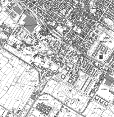
Abstract: La Carta Tecnica Regionale (C.T.R.) rappresenta in scala 1:10.000 il territorio, sia gli elementi naturali (idrografia, forme terrestri, vegetazione, orografia) che quelli antropici (infrastrutture, edifici e altre strutture) oltre riportare la toponomastica.La fonte primaria di acquisizione è la fotografia aerea e la tecnica impiegata per la sua realizzazione è areofotogrammetrica stereoscopica.Realizzata dal 1993 in poi, è aggiornata per lotti.
-
Language: Italian
-
Character set: UTF-8, 8-bit variable size UCS Transfer Format
-
Thumbnail:
-
-
-
???catalog.schedaMetadati.thumbnail.url: https://www502.regione.toscana.it/geonetwork/srv/api/records/r_toscan:414f8ed8-9201-43dd-999d-d5ae5b2e7764/attachments/rt015%20CTR10K%20414%20.png
-
???catalog.schedaMetadati.thumbnail.description: rt015%20CTR10K%20414%20.png
-
Information:
-
Title: Regione Toscana - Carta Tecnica Regionale Numerica 1:10000
-
Date:
-
-
Date 1993-01-01
-
Date Type Creation Date
-
Date:
-
-
Date 2001-01-01
-
Date Type Publication Date
-
Date:
-
-
Date 2016-01-01
-
Date Type Revision Date
-
Resource responsible:
-
Organization name: Regione Toscana
-
Role: Owner
-
Contact Info:
-
E-mail: urp@regione.toscana.it
-
Contact point:
-
-
Organization name: Regione Toscana - Settore Sistema Informativo e Pianificazione del Territorio
-
Role: Point Of Contact
-
Contact Info:
-
E-mail: contatto.cartografia@regione.toscana.it
-
Presentation format: mapDigital
-
Type of spatial representation: Vectorial data
-
Equivalent Scale: 1: 10000
-
ISO topic categories:
- imagery BaseMaps EarthCover
- inland Waters
- boundaries
- location
- structure
- utilities - Communication
-
Keywords:
-
-
Keyword: EU
-
Keyword: RNDT
-
Keyword: Edifici
-
Keyword: Idrografia
-
Keyword: Servizi di pubblica utilità e servizi amministrativi
-
Keyword: Unità amministrative
-
Keyword: Reti di trasporto
-
Thesaurus:
-
Title: GEMET - INSPIRE themes, version 1.0
-
Date:
-
-
Date 2008-06-01
-
Date Type Publication Date
-
Keyword: mappa
-
Keyword: geografia
-
Keyword: carta (geografia)
-
Thesaurus:
-
Title: GEMET
-
Date:
-
-
Date 2018-08-16
-
Date Type Publication Date
-
Keyword: Carta tecnica regionale numerica
-
Thesaurus:
-
Title: Registro dei dati di interesse generale per il RNDT
-
Date:
-
-
Date 2018-06-25
-
Date Type Publication Date
-
Keyword: opendata
-
Keyword: Regionale
-
Thesaurus:
-
Title: Spatial scope
-
Date:
-
-
Date 2019-05-22
-
Date Type Publication Date
-
Geographical area:
-
-
West Bounding Longitude 9.59
-
East Bounding Longitude 12.46
-
North Bounding Latitude 44.45
-
South Bounding Latitude 42.24
-
Other details and supplemental information:
-
Cod.RT: 15 - CTR10K - 414
-
Use Limitation: no conditions apply
-
Legal Constraints:
-
-
Access Contraints:
-
Other Constraints:
-
Legal Constraints:
-
-
Usage Constraints: Other Restrictions
-
Other Constraints: La risorsa è liberamente accessibile e usabile con licenza CC BY
Distribution
-
Distribution Format:
-
-
Format Name ESRI Shapefile
-
Format Version 1.0
-
Distribution Format:
-
-
Format Name DXF
-
Format Version 12
-
Distribution Format:
-
-
Format Name TIFF
-
Format Version 1.0
-
Transfer Options:
-
-
URL: https://www502.regione.toscana.it/geoscopio/cartoteca.html
-
Distributor:
-
-
Distributor Contact:
-
-
Organization name: Regione Toscana - Settore Sistema Informativo e Pianificazione del Territorio
-
Role: Distributor
-
Contact Info:
-
E-mail: contatto.cartografia@regione.toscana.it
Quality
-
Quality level: Dataset
-
Conformity:
-
-
Conformity Level: Not evaluated
-
Description: Fare riferimento alle specifiche indicate
-
Conformity:
-
-
Title: REGOLAMENTO (UE) N. 1089/2010 DELLA COMMISSIONE del 23 novembre 2010 recante attuazione della direttiva 2007/2/CE del Parlamento europeo e del Consiglio per quanto riguarda l'interoperabilità dei set di dati territoriali e dei servizi di dati territoriali
-
Date:
-
-
Date 2010-12-08
-
Date Type Publication Date
-
Positional accuracy:
-
-
Value: m 2.5 m
-
Lineage: La tecnica di esecuzione è la fotogrammetria analitica, ora digitale, che consente di memorizzare direttamente su supporto informatico le primitive geometriche (punti, linee e poligoni) acquisite attribuendo ad ogni oggetto il codice di competenza, secondo la legenda adottata (Tavola dei Contenuti e segni grafici). Al dato geometrico viene poi associato, per i codici cui è previsto, un record alfanumerico riportante gli attributi informativi.