Visualizza questa pagina nel portale RNDT
Information on Metadata
-
File Identifier: r_toscan:1fc4d00b-a5ed-4af9-a9b3-13abfb156b52
-
Metadata Language: Italian
-
Metadata Character Set utf8
-
Hierarchy level: Dataset
-
Metadata Responsibile:
-
Organization name: Regione Toscana
-
Role: Point Of Contact
-
Contact Info:
-
E-mail: sandra.grani@regione.toscana.it
-
Metadata Responsibile:
-
Organization name: Regione Toscana - Settore Sistema Informativo e Pianificazione del Territorio
-
Role: Point Of Contact
-
Contact Info:
-
Phone:
-
E-mail: contatto.cartografia@regione.toscana.it
-
Website:
-
Metadata Date Stamp: 2025-02-10
-
Standard name: Linee Guida RNDT
-
Standard version: 2.0
Reference System Information
-
Reference System Information: RDN2008 / UTM zone 32N (N-E)
Data information
-
Identifier: r_toscan:1fc4d00b-a5ed-4af9-a9b3-13abfb156b52
-
Series ID: r_toscan:1fc4d00b-a5ed-4af9-a9b3-13abfb156b52
-
Abstract: Localizzazione delle aree interessate dal Piano d’azione degli assi stradali principali nella quarta fase di attuazione della Direttiva 2002/49/CE “relativa alla determinazione e gestione del rumore ambientale” (Direttiva END).
-
Language: Italian
-
Character set: UTF-8, 8-bit variable size UCS Transfer Format
-
Thumbnail:
-
-
-
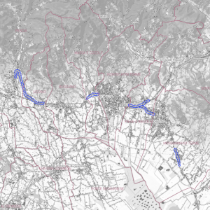
???catalog.schedaMetadati.thumbnail.url: https://www502.regione.toscana.it/geonetwork/srv/api/records/r_toscan:1fc4d00b-a5ed-4af9-a9b3-13abfb156b52/attachments/rt183%20PiaAssiStra%201fc.png
-
???catalog.schedaMetadati.thumbnail.description: rt183 PiaAssiStra 1fc.png
-
Information:
-
Title: Regione Toscana - Piano d’azione degli assi stradali principali 2024 (DF7_10)
-
Date:
-
-
Date 2024-07-15
-
Date Type Creation Date
-
Date:
-
-
Date 2025-01-15
-
Date Type Publication Date
-
Date:
-
-
Date 2025-01-15
-
Date Type Revision Date
-
Resource responsible:
-
Organization name: Regione Toscana
-
Role: Owner
-
Contact Info:
-
E-mail: urp@regione.toscana.it
-
Organization name: ARPAT
-
Role: Principal Investigator
-
Contact Info:
-
E-mail: urp@arpat.toscana.it
-
Contact point:
-
-
Organization name: Settore Viabilità regionale ambiti Arezzo, Siena e Grosseto. Programmazione risanamento acustico
-
Role: Point Of Contact
-
Contact Info:
-
E-mail: sandra.grani@regione.toscana.it
-
Presentation format: mapDigital
-
Update frequency: When needed
-
Type of spatial representation: Vectorial data
-
Equivalent Scale: 1: 10000
-
ISO topic categories:
- environment
- transportation
-
Keywords:
-
-
Keyword: Salute umana e sicurezza
-
Keyword: Reti di trasporto
-
Thesaurus:
-
Title: GEMET - INSPIRE themes, version 1.0
-
Date:
-
-
Date 2008-06-01
-
Date Type Publication Date
-
Keyword: EU
-
Keyword: Regionale
-
Thesaurus:
-
Title: Spatial scope
-
Date:
-
-
Date 2019-05-22
-
Date Type Publication Date
-
Keyword: piano di esposizione al rumore
-
Thesaurus:
-
Title: GEMET
-
Date:
-
-
Date 2018-08-16
-
Date Type Publication Date
-
Keyword: opendata
-
Keyword: RNDT
-
Keyword: Direttiva 2002/49/EC
-
Thesaurus:
-
Title: INSPIRE priority data set
-
Date:
-
-
Date 2018-04-04
-
Date Type Publication Date
-
Geographical area:
-
-
West Bounding Longitude 9.59
-
East Bounding Longitude 12.46
-
North Bounding Latitude 44.45
-
South Bounding Latitude 42.24
-
Temporal Extent:
-
-
Begin Date 2024-01-01
-
End Date 2024-12-31
-
Other details and supplemental information:
-
Cod.RT: 183 - PiaAssiStra - 1fc
-
Use Limitation: Nessuna condizione applicabile
-
Legal Constraints:
-
-
Access Contraints:
-
Other Constraints:
-
Legal Constraints:
-
-
Usage Constraints: Other Restrictions
-
Other Constraints: Nessun vincolo
Distribution
-
Distribution Format:
-
-
Format Name geopackage+sqlite3
-
Format Version 1.x
-
Transfer Options:
-
-
URL: http://www502.regione.toscana.it/geoscopio/inquinamentifisici.html
-
Transfer Options:
-
-
URL: http://www502.regione.toscana.it/geoscopio_qg/cgi-bin/qgis_mapserv?map=mappe_acustiche_rt.qgs
-
Transfer Options:
-
-
URL: https://www502.regione.toscana.it/geoscopio/download/tematici/inqfis/piani_azione/Piano_azione_degli_assi_stradali_principali_2024_(DF7_10).zip
-
Distributor:
-
-
Distributor Contact:
-
-
Organization name: Regione Toscana - Settore Sistema Informativo e Pianificazione del Territorio
-
Role: Distributor
-
Contact Info:
-
E-mail: contatto.cartografia@regione.toscana.it
Quality
-
Quality level: Dataset
-
Conformity:
-
-
Conformity Level: Not evaluated
-
Description: Fare riferimento alle specifiche indicate
-
Conformity:
-
-
Title: REGOLAMENTO (UE) N. 1089/2010 DELLA COMMISSIONE del 23 novembre 2010 recante attuazione della direttiva 2007/2/CE del Parlamento europeo e del Consiglio per quanto riguarda l'interoperabilità dei set di dati territoriali e dei servizi di dati territoriali
-
Date:
-
-
Date 2010-12-08
-
Date Type Publication Date
-
Positional accuracy:
-
-
Value: m 10 m
-
Lineage: A partire dai dati di esposizione al rumore della popolazione derivanti dalla mappatura acustica degli assi stradali principali (2022), la procedura geometrico-analitica utilizzata per originare il dato prevede l’attribuzione, alle singole aree, di un indice di priorità che tiene conto: dell’entità del superamento di soglie prestabilite di livelli di rumore (definiti dagli indicatori Lden e Lnight), della superficie delle aree e del numero stimato di abitanti coinvolti. Le aree interessate dal Piano d’azione sono state selezionate tra quelle che presentano l’indice di priorità più elevato.