Visualizza questa pagina nel portale RNDT
Information on Metadata
-
File Identifier: r_piemon:57ac0ec6-d439-408c-964a-91c20eb1741a
-
Metadata Language: Italian
-
Metadata Character Set utf8
-
Hierarchy level: Dataset
-
Metadata Responsibile:
-
Organization name: CSI Piemonte
-
Role: Point Of Contact
-
Contact Info:
-
Phone:
-
E-mail: info-geoportale@regione.piemonte.it
-
Website: http://www.csipiemonte.it
-
Metadata Date Stamp: 2020-12-04
-
Standard name: Linee Guida RNDT
-
Standard version: 2.0
Reference System Information
-
Reference System Information: WGS84/UTM 32N
Data information
-
Identifier: r_piemon:57ac0ec6-d439-408c-964a-91c20eb1741a
-
Series ID: r_piemon:57ac0ec6-d439-408c-964a-91c20eb1741a
-
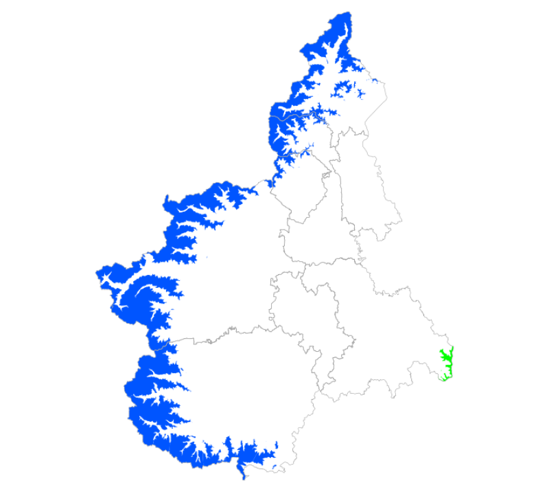
Abstract: Delimitazioni delle aree della catena alpina con quota superiore ai 1600 metri s.l.m. e delle aree della catena appenninica con quota superiore ai 1200 metri s.l.m. presenti nella regione Piemonte, sulla base della cartografia IGM alla scala 1:100.000.
-
Language: Italian
-
Character set: UTF-8, 8-bit variable size UCS Transfer Format
-
Thumbnail:
-
-

-
???catalog.schedaMetadati.thumbnail.url: https://www.geoportale.piemonte.it/geonetwork/srv/api/records/r_piemon:57ac0ec6-d439-408c-964a-91c20eb1741a/attachments/aree_montane_STORICO_s.png
-
???catalog.schedaMetadati.thumbnail.type: png
-
???catalog.schedaMetadati.thumbnail.description: thumbnail
-
-
???catalog.schedaMetadati.thumbnail.url: https://www.geoportale.piemonte.it/geonetwork/srv/api/records/r_piemon:57ac0ec6-d439-408c-964a-91c20eb1741a/attachments/aree_montane_STORICO.png
-
???catalog.schedaMetadati.thumbnail.type: png
-
???catalog.schedaMetadati.thumbnail.description: large_thumbnail
-
Information:
-
Title: Aree montane 1:100.000 - Storico
-
Date:
-
-
Date 1966-01-01
-
Date Type Revision Date
-
Date:
-
-
Date 2008-02-21
-
Date Type Creation Date
-
Resource responsible:
-
Organization name: Regione Piemonte - A1613B - Sistema informativo territoriale e ambientale
-
Role: Custodian
-
Contact Info:
-
Phone:
-
E-mail: cartografico@regione.piemonte.it
-
Website: https://www.regione.piemonte.it/web/temi/ambiente-territorio/territorio/infrastruttura-geografica-cartografia
-
Organization name: Regione Piemonte
-
Role: Owner
-
Contact Info:
-
Phone:
-
E-mail: info-geoportale@regione.piemonte.it
-
Website: https://www.regione.piemonte.it
-
Contact point:
-
-
Organization name: CSI Piemonte
-
Role: Author
-
Contact Info:
-
Phone:
-
E-mail: info-geoportale@regione.piemonte.it
-
Website: http://www.csipiemonte.it
-
Organization name: Regione Piemonte - A1613B - Sistema informativo territoriale e ambientale
-
Role: Point Of Contact
-
Contact Info:
-
Phone:
-
E-mail: cartografico@regione.piemonte.it
-
Website: https://www.regione.piemonte.it/web/temi/ambiente-territorio/territorio/infrastruttura-geografica-cartografia
-
Presentation format: mapDigital
-
Update frequency: When needed
-
Type of spatial representation: Vectorial data
-
Equivalent Scale: 1: 100000
-
ISO topic categories:
- imagery BaseMaps EarthCover
-
Keywords:
-
-
Keyword: RNDT
-
Keyword: EU
-
Keyword: opendata
-
Keyword: storico
-
Keyword: Utilizzo del territorio
-
Thesaurus:
-
Title: GEMET - INSPIRE themes, version 1.0
-
Date:
-
-
Date 2008-06-01
-
Date Type Publication Date
-
Keyword: montagna
-
Thesaurus:
-
Title: GEMET - Concepts, version 2.4
-
Date:
-
-
Date 2010-01-13
-
Date Type Publication Date
-
Keyword: Regionale
-
Thesaurus:
-
Title: Spatial scope
-
Date:
-
-
Date 2019-05-22
-
Date Type Publication Date
-
Geographical area:
-
-
West Bounding Longitude 6.62
-
East Bounding Longitude 9.21
-
North Bounding Latitude 46.46
-
South Bounding Latitude 44.06
-
Temporal Extent:
-
-
Begin Date 2008-02-21
-
End Date 2008-12-31
-
Other details and supplemental information:
-
Componente di base nella definizione delle aree vincolate ai sensi dell'Art. 146 del D.Lgs. n. 490 del 29/10/99 (lettera d) sostituente la precedente legge 431/85 (aree Galasso).
-
Legal Constraints:
-
-
Access Contraints:
-
Other Constraints:
-
Legal Constraints:
-
-
Usage Constraints: Other Restrictions
-
Other Constraints: https://creativecommons.org/licenses/by/4.0/deed.it
Distribution
-
Distribution Format:
-
-
Format Name Aree (SHP)
-
Format Version N.A.
-
Transfer Options:
-
-
URL: https://www.datigeo-piem-download.it/direct/Geoportale/RegionePiemonte/Aree_montane/Aree_montane_storico.zip
-
Distributor:
-
-
Distributor Contact:
-
-
Organization name: Regione Piemonte - A1613B - Sistema informativo territoriale e ambientale
-
Role: Distributor
-
Contact Info:
-
Phone:
-
E-mail: cartografico@regione.piemonte.it
-
Website: https://www.regione.piemonte.it/web/temi/ambiente-territorio/territorio/infrastruttura-geografica-cartografia
Quality
-
Quality level: Dataset
-
Conformity:
-
-
Conformity Level: Not evaluated
-
Description: Fare riferimento alle specifiche indicate
-
Conformity:
-
-
Title: REGOLAMENTO (UE) N. 1089/2010 DELLA COMMISSIONE del 23 novembre 2010 recante attuazione della direttiva 2007/2/CE del Parlamento europeo e del Consiglio per quanto riguarda l'interoperabilità dei set di dati territoriali e dei servizi di dati territoriali
-
Date:
-
-
Date 2010-12-08
-
Date Type Publication Date
-
Positional accuracy:
-
-
Value: m 40 m
-
Lineage: delimitazione delle aree comprese tra le isoipse a q 1600 e superiori e q 1200 e superiori, a partire dal dataset Altimetria 1:100.000 - Isoipse (STORICO)