Visualizza questa pagina nel portale RNDT
Information on Metadata
-
File Identifier: p_AR:af689f37-82fd-4d68-82d0-681f70f8d2eb
-
Metadata Language: Italian
-
Metadata Character Set utf8
-
Hierarchy level: Dataset
-
Metadata Responsibile:
-
Organization name: Artel Spa
-
Role: Point Of Contact
-
Contact Info:
-
Phone: 0575 392600
-
E-mail: info@ar-tel.it
-
Website: www.ar-tel.it
-
Metadata Date Stamp: 2023-12-21
-
Standard name: Linee Guida RNDT
-
Standard version: 2.0
Reference System Information
-
Reference System Information: Monte-Mario-Italy1
Data information
-
Identifier: p_AR:af689f37-82fd-4d68-82d0-681f70f8d2eb
-
Series ID: p_AR:af689f37-82fd-4d68-82d0-681f70f8d2eb
-
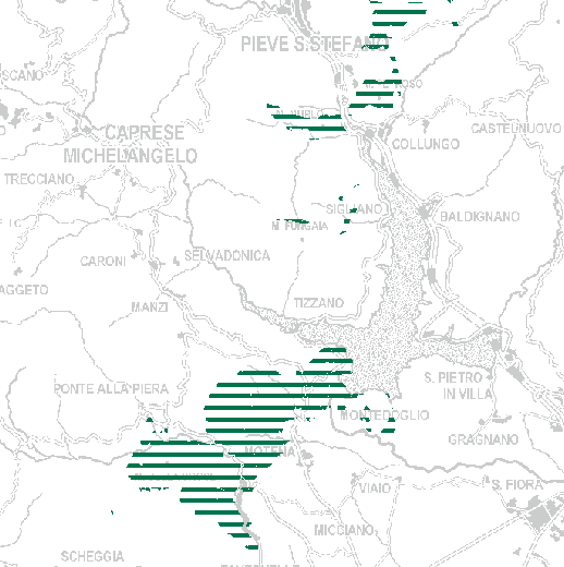
Abstract: Ecosistemi rupestri, mosaici di praterie aride e garighe e formazioni forestali (perlopiù di conifere) presenti su litosuoli oliofitici a costituire paesaggi di elevato interesse naturalistico.Tali ecosistemi ad elevata caratterizzazione geologica si localizzano in Valtiberina,estendendosi sui rilievi dei Monti Rognosi o dei poggi circostanti Pieve Santo Stefano, ed ospitando numerosi habitat di interesse comunitario, specie vegetali serpentinofite ed endemiche dei suoli ofiolitici e specie animali di interesse conservazionistico.
-
Language: Italian
-
Character set: UTF-8, 8-bit variable size UCS Transfer Format
-
Thumbnail:
-
-

-
???catalog.schedaMetadati.thumbnail.url: https://geonetwork.ar-tel.it:/geonetwork/srv/api/records/p_AR:af689f37-82fd-4d68-82d0-681f70f8d2eb/attachments/QP_05_INV_II_strutt_ecosist_II_e.PNG
-
???catalog.schedaMetadati.thumbnail.description: STRUTTURA ECOSISTEMICA (INVARIANTE II) Ecosistemi ofiolitici con garighe, praterie aride e boschi (II.e)
-
Information:
-
Title: PTC - STRUTTURA ECOSISTEMICA (INVARIANTE II) Ecosistemi ofiolitici con garighe, praterie aride e boschi (II.e)
-
Date:
-
-
Date 2022-10-19
-
Date Type Publication Date
-
Resource responsible:
-
Organization name: Provincia di Arezzo
-
Role: Owner
-
Contact Info:
-
Phone: 0575 3921
-
E-mail: urp@provincia.arezzo.it
-
Website: www.provincia.arezzo.it
-
Organization name: Ufficio Pianificazione Territoriale
-
Role: Author
-
Contact Info:
-
Phone: 0575 392575
-
E-mail: svanni@provincia.arezzo.it
-
Website: www.pianificazioneterritoriale.provincia.arezzo.it
-
Contact point:
-
-
Organization name: Ufficio Pianificazione Territoriale
-
Role: Point Of Contact
-
Contact Info:
-
Phone: 0575 392575
-
E-mail: svanni@provincia.arezzo.it
-
Website: www.pianificazioneterritoriale.provincia.arezzo.it
-
Organization name: Artel Spa
-
Role: Distributor
-
Contact Info:
-
Phone: 0575 392600
-
E-mail: info@ar-tel.it
-
Website: www.ar-tel.it
-
Presentation format: mapDigital
-
Update frequency: When needed
-
Type of spatial representation: Vectorial data
-
Equivalent Scale: 1: 10000
-
ISO topic categories:
- biota
-
Keywords:
-
-
Keyword: Copertura del suolo
-
Thesaurus:
-
Title: GEMET - INSPIRE themes, version 1.0
-
Date:
-
-
Date 2008-06-01
-
Date Type Publication Date
-
Keyword: opendata
-
Geographical area:
-
-
West Bounding Longitude 11.3824
-
East Bounding Longitude 12.3807
-
North Bounding Latitude 43.8596
-
South Bounding Latitude 43.1679
-
Other details and supplemental information:
- https://webgis2.ar-tel.it/ptcp/ptcp/
-
Legal Constraints:
-
-
Access Contraints:
-
Other Constraints:
-
Legal Constraints:
-
-
Usage Constraints: Other Restrictions
-
Other Constraints:
Distribution
-
Distribution Format:
-
-
Format Name ESRI Shapefile
-
Format Version 1.0
-
Transfer Options:
-
-
URL: https://webgis2.ar-tel.it/PTCP/QP_05/opendata/ZIP/QP_05_INV_II_strutt_ecosist_II_e.zip
-
Transfer Options:
-
-
URL: https://webgis2.ar-tel.it/arcgis/services/OPENDATA/QP_05_INV_II_strutt_ecosist_II_e/MapServer/WMSServer
-
Transfer Options:
-
-
URL: https://webgis2.ar-tel.it/arcgis/services/OPENDATA/QP_05_INV_II_strutt_ecosist_II_e/MapServer/WFSServer?service=WFS&version=2.0.0
-
Transfer Options:
-
-
URL: https://webgis2.ar-tel.it/ptcp/ptcp
-
Distributor:
-
-
Distributor Contact:
-
-
Organization name: Artel Spa
-
Role: Distributor
-
Contact Info:
-
Phone: 0575 392600
-
E-mail: info@ar-tel.it
Quality
-
Quality level: Dataset
-
Conformity:
-
-
Conformity Level: Not evaluated
-
Description: non valutato
-
Conformity:
-
-
Title: REGOLAMENTO (UE) N. 1089/2010 DELLA COMMISSIONE del 23 novembre 2010 recante attuazione della direttiva 2007/2/CE del Parlamento europeo e del Consiglio per quanto riguarda l'interoperabilità dei set di dati territoriali e dei servizi di dati territoriali
-
Date:
-
-
Date 2010-12-08
-
Date Type Publication Date
-
Positional accuracy:
-
-
Value: m 0.0001 m
-
Lineage: Selezione delle patch di ecosistemi della tavola QC9 che si sovrappongono al tematismo geologico degli affioramento ofiolitici derivante dal tematismo delle Unità geologiche di Regione Toscana (sigla cart= pm o BROe o m).